 Filter: Categories of Wisconsin Historical Images
Filter: Subject of Formations (Geology)
Filter: Creator Name of Unknown
Filter: Subject of water
Filter: Categories of Wisconsin Historical Images
Filter: Subject of Formations (Geology)
Filter: Creator Name of Unknown
Filter: Subject of water

| Date: | |
|---|---|
| Description: | A hand-drawn Geological map of the Upper Peninsula of Michigan, showing the counties and streams of that area. The map also identifies the location of the... |

| Date: | 1911 |
|---|---|
| Description: | This map, taken from the 1911 Map of Wisconsin showing geology and roads by Hotchkiss and Thwaites, shows the northwest portion of Douglas County, Wisconsi... |

| Date: | 1930 |
|---|---|
| Description: | Shows county system of roads which are surfaced, well graded, common, or unimproved, town roads, state trunk highways, town and village boundaries, schools... |
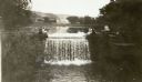
| Date: | 1935 |
|---|---|
| Description: | Five women pose at the dam built by Frank Lloyd Wright at his home near Spring Green, Wisconsin. A sixth figure is obscured by tree branches on the right. ... |
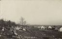
| Date: | 1910 |
|---|---|
| Description: | Photographic postcard view across rocky field of dwellings and other buildings along Lake Michigan. Along the left is a rocky ledge. The shoreline of the h... |

| Date: | 1934 |
|---|---|
| Description: | Photographic postcard view along the rocky shoreline of Lake Michigan towards a long pier that jutts out behind the rocky point. Caption reads: "Along the ... |

| Date: | |
|---|---|
| Description: | A stereoscopic view from the shore of Maiden Rock in Lake Pepin. |

| Date: | |
|---|---|
| Description: | Photographic postcard view of a covered bridge over the Wisconsin River. Men are fishing at the base of a pylon, and other men are boating in the river. Th... |

| Date: | |
|---|---|
| Description: | Photographic postcard view of two steamboats on the Wisconsin River. Tree-covered bluffs are on the opposite shoreline. The steamboat on the left is the "G... |

| Date: | 05 16 1908 |
|---|---|
| Description: | View across water of the summer cottages on Maple Bluff. |

| Date: | 05 16 1908 |
|---|---|
| Description: | A view from the west of Maple Bluff. Part of the roof of a cottage can be seen above the bluff. |

| Date: | 05 16 1908 |
|---|---|
| Description: | View across water of Governor's Island. There is a far shoreline in the background on the left. |

| Date: | 1940 |
|---|---|
| Description: | Woman seated on flat rocks, watching rushing water of the Wolf River. |

| Date: | 1698 |
|---|---|
| Description: | An illustration of two men looking out at Niagara Falls. The Niagara Falls in Jean Louis Hennepin’s A new discovery of a vast country in America (London: M... |

| Date: | 1918 |
|---|---|
| Description: | View from shoreline of three men standing in the water at Mechanic's Rock on the Mississippi River. |

| Date: | 1900 |
|---|---|
| Description: | View from rocky shoreline across river towards a man standing on rocks and holding a stick in front of a rock face on the opposite shoreline. There are lar... |
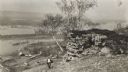
| Date: | 1915 |
|---|---|
| Description: | Elevated view of the Mississippi River from a bluff. There is a farm and other houses along the shoreline, and in the foreground a boy stands on the bluff ... |
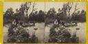
| Date: | 1860 |
|---|---|
| Description: | Two men and two women visit sit on a small, rocky island or natural bridge near water. Plants and trees are on shoreline behind them. |

| Date: | 1900 |
|---|---|
| Description: | Elevated view of a landscape from the bluffs along the Mississippi River, over Lake Pepin, looking toward Lake City. |
If you didn't find the material you searched for, our Library Reference Staff can help.
Call our reference desk at 608-264-6535 or email us at:
