Filter: Categories of Wisconsin Historical Images
Filter: Subject of Forests and forestry
Filter: Categories of Wisconsin Historical Images
Filter: Subject of Forests and forestry

| Date: | 1921 |
|---|---|
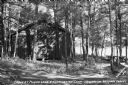
| Description: | A high wooden pedestrian bridge along a forest path, crossing over a deep gorge. |
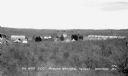
| Date: | 1934 |
|---|---|
| Description: | Elevated view of the forest and the two-story Forest Ranger Station with two automobiles parked out front. |
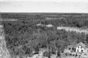
| Date: | 1934 |
|---|---|
| Description: | Elevated view over trees of the Civilian Conservation Corps (CCC) Camp, Moquah National Forest near Washburn, showing two buildings and about twenty-one te... |
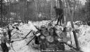
| Date: | 1936 |
|---|---|
| Description: | View of a man standing on top of another man's shoulders, leaning up against a large tree trunk for a tall pine. |
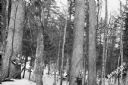
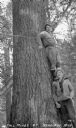
| Date: | 1932 |
|---|---|
| Description: | View of two men who are hunters, each holding a gun and standing next to the tree trunks of large pine trees in a pine forest. |
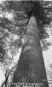
| Date: | 1932 |
|---|---|
| Description: | View looking up from the ground at the tree trunk of a five-foot diameter pine tree. |
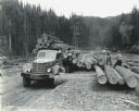
| Date: | 1933 |
|---|---|
| Description: | Three men loading up a logging truck with timber. Two of the men are standing on the ground using pulley's, and the third man is on top of the trailer with... |

| Date: | |
|---|---|
| Description: | View of a horse and wagon traveling down a narrow road through a forest. There is an automobile in the background. |

| Date: | 1861 |
|---|---|
| Description: | Shows townships and sections, landowners, and woodlands. Includes inset maps of Monroe, Brodhead, Albany, Cadiz, Decatur, Dayton, Clarence, Springfield, Tw... |

| Date: | 1958 |
|---|---|
| Description: | Includes images of Flambeau River State Forest and a description of, canoeing and recreational activities in, and general park and forest information about... |

| Date: | 1935 |
|---|---|
| Description: | This map shows Wisconsin’s pinery region. Lake Superior, Lake Michigan, Lake Winnebago, Green Bay, the Wisconsin River, and the Mississippi River are label... |
| Date: | 1940 |
|---|---|
| Description: | Two men are loading logs onto the bed of an International D-Line truck. A forest and mountain are in the background. |
| Date: | 1937 |
|---|---|
| Description: | View of a cabin and picnic table at Pigeon Lake Organization Camp in the Chequamegon National Forest. The cabin is surrounded by trees, and in the distance... |

| Date: | 1933 |
|---|---|
| Description: | View of an automobile parked along the side of the road during a scenic drive through virgin forest near Lac du Flambeau. |
| Date: | |
|---|---|
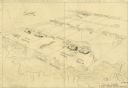
| Description: | This hand-colored map shows the Ranger District boundaryin blue, government lands in green, and "Opt. 9 Appr. Land" in yellow. |

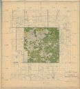
| Date: | 1935 |
|---|---|
| Description: | This map shows in different colors virgin timberland, second growth timber, pasture belt, crop-pasture belt, intensive crop-pasture belt, intensive pasture... |

| Date: | 1933 |
|---|---|
| Description: | A road map of Wisconsin and Michigan’s Upper Peninsula, showing the populations of cities and villages, state and federal highways, national forests, state... |
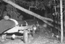
| Date: | 1934 |
|---|---|
| Description: | Night view of an automobile pulling a trailer with a canoe on a dirt road through the forest. A fallen tree trunk is leaning at an angle on another tree ju... |

| Date: | 1938 |
|---|---|
| Description: | View looking down hill of two men and two women having a picnic at a table in the forest. Three automobiles are parked nearby. In the background are trees ... |
If you didn't find the material you searched for, our Library Reference Staff can help.
Call our reference desk at 608-264-6535 or email us at: