 Filter: Categories of Wisconsin Historical Images
Filter: Subject of Forests and forestry
Filter: Year of 1800-1899
Filter: Subject of human settlements
Filter: Categories of Wisconsin Historical Images
Filter: Subject of Forests and forestry
Filter: Year of 1800-1899
Filter: Subject of human settlements

| Date: | 1883 |
|---|---|
| Description: | Bird's-eye map of Sauk City. |
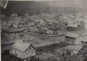
| Date: | 1885 |
|---|---|
| Description: | View of buildings in an industrial area with a forest in the background. |
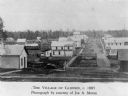
| Date: | 1886 |
|---|---|
| Description: | Elevated view of houses and buildings in Wonewoc. |
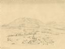
| Date: | 1852 |
|---|---|
| Description: | Landscape featuring a rural city center with a prominent courthouse surrounded by fields and woods. Rolling erosion-softened mountains rise in the backgro... |

| Date: | 1861 |
|---|---|
| Description: | Shows townships and sections, landowners, and woodlands. Includes inset maps of Monroe, Brodhead, Albany, Cadiz, Decatur, Dayton, Clarence, Springfield, Tw... |
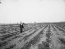
| Date: | 1895 |
|---|---|
| Description: | Two men stand in a strawberry field bordered by burnt-over forest. The photographer's shadow can be seen at the bottom of the image. |

| Date: | 1861 |
|---|---|
| Description: | Shows townships and sections, landowners, and woodlands. Includes inset maps of Monroe, Brodhead, Albany, Cadiz, Decatur, Dayton, Clarence, Springfield, Tw... |

| Date: | 1860 |
|---|---|
| Description: | Map shows meadows, forests, buildings, railroad, and lots south of part of the city of Milwaukee. Relief shown by hachures. Includes list of lot acreages. |

| Date: | 1858 |
|---|---|
| Description: | This map shows city wards, streets, block and lot numbers, cemeteries, buildings, landownership, forests, railroads, a race course, quarries, and orchards.... |

| Date: | 1898 |
|---|---|
| Description: | This map shows the conditions of the forest. Includes a color legend in left margin, depicting the various conditions. Original caption reads, "Compiled by... |

| Date: | 1831 |
|---|---|
| Description: | This map shows the land that makes up Michigan, Wisconsin, Minnesota, Indiana, and parts of Canada. The Great Lakes are displayed prominently, along with s... |

| Date: | 1896 |
|---|---|
| Description: | View along shoreline of the Wisconsin River, with a sandy beach leading to a stand of trees on the bank on the right. Buildings are along the opposite bank... |
If you didn't find the material you searched for, our Library Reference Staff can help.
Call our reference desk at 608-264-6535 or email us at: