 Filter: Categories of Wisconsin Historical Images
Filter: Subject of Forests and forestry
Filter: Year of 1800-1899
Filter: Subject of buildings
Filter: Categories of Wisconsin Historical Images
Filter: Subject of Forests and forestry
Filter: Year of 1800-1899
Filter: Subject of buildings

| Date: | 1861 |
|---|---|
| Description: | Shows townships and sections, landowners, and woodlands. Includes inset maps of Monroe, Brodhead, Albany, Cadiz, Decatur, Dayton, Clarence, Springfield, Tw... |

| Date: | 1861 |
|---|---|
| Description: | Shows townships and sections, landowners, and woodlands. Includes inset maps of Monroe, Brodhead, Albany, Cadiz, Decatur, Dayton, Clarence, Springfield, Tw... |
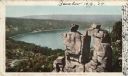
| Date: | 1898 |
|---|---|
| Description: | Colorized postcard view of the Devil's Doorway rock formation overlooking Devil's Lake. Caption reads: "Devil's Doorway, Devil's Lake, Wis." |
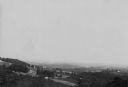
| Date: | 08 1898 |
|---|---|
| Description: | Elevated view along hillsides towards several buildings, forests, and part of a river. Caption reads: "View from N.W. 1/4 of N.W. of Sec. 31. L. 12. R 6 W,... |
If you didn't find the material you searched for, our Library Reference Staff can help.
Call our reference desk at 608-264-6535 or email us at: