 Filter: Categories of Wisconsin Historical Images
Filter: Subject of Forests and forestry
Filter: Subject of water
Filter: Categories of Wisconsin Historical Images
Filter: Subject of Forests and forestry
Filter: Subject of water

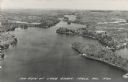
| Date: | 07 15 1958 |
|---|---|
| Description: | Aerial view of Eagle Heights Farm, Eagle Heights Woods and part of Lake Mendota. Sites labeled on the image are Eagle Heights, Tent Colony, Apartment Site,... |
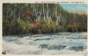
| Date: | 1913 |
|---|---|
| Description: | Colorized postcard view of the Lower Falls on the Brule River flowing through the forest. Some trees are showing autumn color. Caption reads: "Brule River ... |
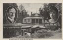
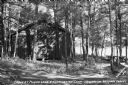
| Date: | 1926 |
|---|---|
| Description: | Black and white postcard view of Cedar Island Lodge, located on the Brule River, owned by Henry Clay Pierce, businessman and financier. It was dubbed the S... |
| Date: | |
|---|---|
| Description: | Black and white postcard view of the wooden Ford Bridge. Trees on a hill are on the far shoreline. Caption reads: "The Ford Bridge Across Willow River, Bur... |

| Date: | |
|---|---|
| Description: | Color view from hill toward a lone boater on Kennedy Lake. Caption reads: "Kennedy Lake, Antigo, Wis." |
| Date: | |
|---|---|
| Description: | Photographic postcard of an aerial view of Lake Owen near Cable. Most of the lake is located within the Chequamegon National Forest. Caption reads: "Air Vi... |

| Date: | |
|---|---|
| Description: | Color postcard of a view of a lake from a shoreline. A power boat and a fishing boat can be seen through the trees. "Cable, Wisc." is printed in red on the... |
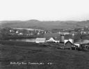
| Date: | 1930 |
|---|---|
| Description: | View from hill of a farm near a pond. There are homes along the far shoreline, and a lake and hills in the far background. |
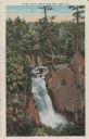
| Date: | |
|---|---|
| Description: | View of water streaming down the rock and tree-lined Tyler Falls. A white walk bridge is in the background. |

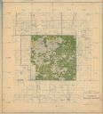
| Date: | 1861 |
|---|---|
| Description: | Shows townships and sections, landowners, and woodlands. Includes inset maps of Monroe, Brodhead, Albany, Cadiz, Decatur, Dayton, Clarence, Springfield, Tw... |

| Date: | 1958 |
|---|---|
| Description: | Includes images of Flambeau River State Forest and a description of, canoeing and recreational activities in, and general park and forest information about... |

| Date: | 1935 |
|---|---|
| Description: | This map shows Wisconsin’s pinery region. Lake Superior, Lake Michigan, Lake Winnebago, Green Bay, the Wisconsin River, and the Mississippi River are label... |
| Date: | 1937 |
|---|---|
| Description: | View of a cabin and picnic table at Pigeon Lake Organization Camp in the Chequamegon National Forest. The cabin is surrounded by trees, and in the distance... |
| Date: | |
|---|---|
| Description: | This hand-colored map shows the Ranger District boundaryin blue, government lands in green, and "Opt. 9 Appr. Land" in yellow. |

| Date: | 1935 |
|---|---|
| Description: | This map shows in different colors virgin timberland, second growth timber, pasture belt, crop-pasture belt, intensive crop-pasture belt, intensive pasture... |
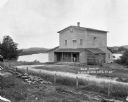
| Date: | 1924 |
|---|---|
| Description: | The Humbird Roller Mill surrounded by rural landscape. A man leads on a porch beam as he poses for the picture. |
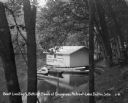
| Date: | 1931 |
|---|---|
| Description: | A boathouse and canoe boats along Lake Delton. The boathouse is painted with advertisements that read, "Cottages - Rooms - Cabins - Refreshments - Free Cam... |

| Date: | |
|---|---|
| Description: | Elevated view of the sun shining through clouds over a lake, identified as Lake Namakagon. In the foreground are trees, and more trees are visible on the o... |

| Date: | |
|---|---|
| Description: | View of the sun shining through clouds over Lake Namakagon. There are trees are visible on the opposite shorelines. Text describing the photograph says, "t... |

| Date: | |
|---|---|
| Description: | Elevated view of the sun shining through clouds over Lake Namakagon. In the foreground are a few trees and in the distance is the opposite shoreline. Text ... |
If you didn't find the material you searched for, our Library Reference Staff can help.
Call our reference desk at 608-264-6535 or email us at: