 Filter: Categories of Wisconsin Historical Images
Filter: Subject of Forests and forestry
Filter: Subject of water
Filter: Year of 1900-1999
Filter: Subject of lakes
Filter: Categories of Wisconsin Historical Images
Filter: Subject of Forests and forestry
Filter: Subject of water
Filter: Year of 1900-1999
Filter: Subject of lakes

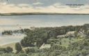
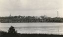
| Date: | 07 10 1949 |
|---|---|
| Description: | Aerial view of Minocqua showing the surrounding lakes. |
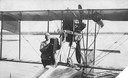
| Date: | 1915 |
|---|---|
| Description: | Jack Vilas (seated) in the Curtiss hydroplane he used to spot forest fires for the Wisconsin Conservation Department. (His companion is not identified.) Th... |
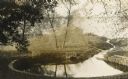
| Date: | 1948 |
|---|---|
| Description: | View from the east bluff of lake with a motorboat. A geologic pinnacle juts out from the lower left of the image. |
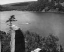
| Date: | 1945 |
|---|---|
| Description: | Elevated view of American Baptist Assembly Grounds from Judson Tower. Below near the tree-covered shoreline are buildings, a recreation area, and a harbor ... |
| Date: | 1910 |
|---|---|
| Description: | Big spring on Lake Mendota Drive. [Merrill Springs or sometimes Merrill's Spring] |
| Date: | 1915 |
|---|---|
| Description: | The University of Wisconsin from Picnic Point. Buildings that can be seen are Bascom Hall with dome, the Students' Observatory, Washburn Observatory, the D... |

| Date: | 03 24 1913 |
|---|---|
| Description: | Picnic Point from the University Farm fields, now known as Observatory Hill. |

| Date: | 1930 |
|---|---|
| Description: | Aerial view of the University of Wisconsin-Madison Arboretum including a portion of Lake Wingra and surrounding residential neighborhoods. |

| Date: | 1910 |
|---|---|
| Description: | Aerial view of some of the 26 lakes known collectively as the Chain O' Lakes. Caption reads: "Aeroplane View of Chain O'Lakes, Waupaca, Wis." |
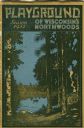
| Date: | 1931 |
|---|---|
| Description: | Cover of a Wisconsin tourism pamphlet for the 1932 season. |

| Date: | 1939 |
|---|---|
| Description: | A color, pictorial map. Scale: 10 miles to the inch. Shows state parks and forests, proposed state parkways, proposed state monuments and memorials, nation... |
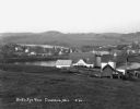
| Date: | 1935 |
|---|---|
| Description: | Barracks buildings at the Crystal Lake Civilian Conservation Corps (CCC) camp. |

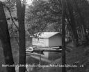
| Date: | 05 30 1962 |
|---|---|
| Description: | View down steep hill towards a small lake in a tree-lined valley. |

| Date: | 07 15 1958 |
|---|---|
| Description: | Aerial view of Eagle Heights Farm, Eagle Heights Woods and part of Lake Mendota. Sites labeled on the image are Eagle Heights, Tent Colony, Apartment Site,... |
| Date: | 1930 |
|---|---|
| Description: | View from hill of a farm near a pond. There are homes along the far shoreline, and a lake and hills in the far background. |

| Date: | 1935 |
|---|---|
| Description: | This map shows Wisconsin’s pinery region. Lake Superior, Lake Michigan, Lake Winnebago, Green Bay, the Wisconsin River, and the Mississippi River are label... |
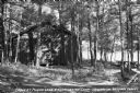
| Date: | 1937 |
|---|---|
| Description: | View of a cabin and picnic table at Pigeon Lake Organization Camp in the Chequamegon National Forest. The cabin is surrounded by trees, and in the distance... |

| Date: | 1935 |
|---|---|
| Description: | This map shows in different colors virgin timberland, second growth timber, pasture belt, crop-pasture belt, intensive crop-pasture belt, intensive pasture... |
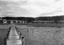
| Date: | 1931 |
|---|---|
| Description: | A boathouse and canoe boats along Lake Delton. The boathouse is painted with advertisements that read, "Cottages - Rooms - Cabins - Refreshments - Free Cam... |

| Date: | 1935 |
|---|---|
| Description: | This three-part map from the U.S. Bureau of Public Roads identifies highways in Wisconsin that have been improved, indicating those which are federal highw... |
If you didn't find the material you searched for, our Library Reference Staff can help.
Call our reference desk at 608-264-6535 or email us at: