 Filter: Categories of Wisconsin Historical Images
Filter: Subject of Forests and forestry
Filter: Subject of water
Filter: Subject of land
Filter: Year of 1900-1999
Filter: Categories of Wisconsin Historical Images
Filter: Subject of Forests and forestry
Filter: Subject of water
Filter: Subject of land
Filter: Year of 1900-1999

| Date: | 07 10 1949 |
|---|---|
| Description: | Aerial view of Minocqua showing the surrounding lakes. |
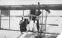
| Date: | 1915 |
|---|---|
| Description: | Jack Vilas (seated) in the Curtiss hydroplane he used to spot forest fires for the Wisconsin Conservation Department. (His companion is not identified.) Th... |

| Date: | 06 05 1989 |
|---|---|
| Description: | People costumed as Smokey The Bear and Woodsy Owl play outdoors with children as a forest service worker looks on. |

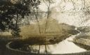
| Date: | 1902 |
|---|---|
| Description: | River with distant hills behind a town. An island is in the foreground. |
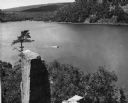
| Date: | 1948 |
|---|---|
| Description: | View from the east bluff of lake with a motorboat. A geologic pinnacle juts out from the lower left of the image. |
| Date: | 1910 |
|---|---|
| Description: | Big spring on Lake Mendota Drive. [Merrill Springs or sometimes Merrill's Spring] |
| Date: | 1915 |
|---|---|
| Description: | The University of Wisconsin from Picnic Point. Buildings that can be seen are Bascom Hall with dome, the Students' Observatory, Washburn Observatory, the D... |

| Date: | 03 24 1913 |
|---|---|
| Description: | Picnic Point from the University Farm fields, now known as Observatory Hill. |
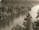
| Date: | 1940 |
|---|---|
| Description: | Elevated view of a canoe on the St. Croix River with wooded areas on both sides within the Interstate State Park. Established in 1900, Interstate Park was... |

| Date: | 1930 |
|---|---|
| Description: | Aerial view of the University of Wisconsin-Madison Arboretum including a portion of Lake Wingra and surrounding residential neighborhoods. |

| Date: | 1910 |
|---|---|
| Description: | Aerial view of some of the 26 lakes known collectively as the Chain O' Lakes. Caption reads: "Aeroplane View of Chain O'Lakes, Waupaca, Wis." |

| Date: | 09 1962 |
|---|---|
| Description: | The Mississippi River along Highway 35. |

| Date: | 1930 |
|---|---|
| Description: | A view looking west at Rib Mountain across the Wisconsin River from the outskirts of Wausau. |

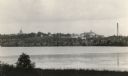
| Date: | 1939 |
|---|---|
| Description: | A color, pictorial map. Scale: 10 miles to the inch. Shows state parks and forests, proposed state parkways, proposed state monuments and memorials, nation... |
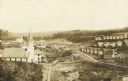
| Date: | 1910 |
|---|---|
| Description: | An elevated view of town. A church is on the left, houses are in rows on the right. Caption reads: "Made-For-Club-House — Niagara-Wis.—". |

| Date: | 1900 |
|---|---|
| Description: | Group of four standing on the rocks along shore of the Wisconsin River at the Wisconsin Dells. |

| Date: | 1900 |
|---|---|
| Description: | Crowded steamboat touring the Wisconsin Dells. There is a group of four people standing on the shore of the Wisconsin River looking on. |

| Date: | 06 23 1937 |
|---|---|
| Description: | A man in an International D-30 truck used by the Township of Monck is parked in front of a wooded area and body of water. He is talking to a man standing n... |
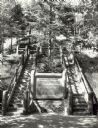
| Date: | 1940 |
|---|---|
| Description: | Two rustic stairways leading down to the Bad River at Copper Falls State Park. At the bottom of the stairs is a sign telling the geological story of Copper... |

| Date: | 07 1940 |
|---|---|
| Description: | Two boys and two girls swimming at the Bad River at Copper Falls State Park. One of the girls is diving off the dock that also has a platform. In the backg... |
If you didn't find the material you searched for, our Library Reference Staff can help.
Call our reference desk at 608-264-6535 or email us at: