Filter: Categories of Wisconsin Historical Images
Filter: Subject of Forests and forestry
Filter: Subject of water
Filter: Subject of land
Filter: Categories of Wisconsin Historical Images
Filter: Subject of Forests and forestry
Filter: Subject of water
Filter: Subject of land

| Date: | 10 1852 |
|---|---|
| Description: | Landscape view of the river looking downstream from Fort Snelling, Minnesota Territory. An expanse of placid river water fills the center of the drawing an... |
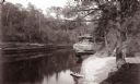
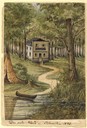
| Date: | |
|---|---|
| Description: | Elevated view of the mouth of Chapel Gorge Beach showing a canoe at the shore. |

| Date: | 07 10 1949 |
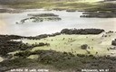
|---|---|
| Description: | Aerial view of Minocqua showing the surrounding lakes. |
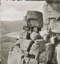
| Date: | |
|---|---|
| Description: | Devil's Lake vicinity; Boulders on top of cliff, at foot of Devil's Doorway; man on the left. |
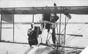
| Date: | 1915 |
|---|---|
| Description: | Jack Vilas (seated) in the Curtiss hydroplane he used to spot forest fires for the Wisconsin Conservation Department. (His companion is not identified.) Th... |

| Date: | 1883 |
|---|---|
| Description: | Bird's-eye map of Sauk City. |
| Date: | 06 05 1989 |
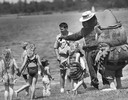
|---|---|
| Description: | People costumed as Smokey The Bear and Woodsy Owl play outdoors with children as a forest service worker looks on. |
| Date: | 1858 |
|---|---|
| Description: | This house, built on a hill close to the Milwaukee River, was the only one in the city as late as 1840. The owner of the house, Martin [Matthias] Stein, a ... |
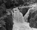
| Date: | |
|---|---|
| Description: | Elevated view of the falls. There are three men at the top of the falls. |

| Date: | 1902 |
|---|---|
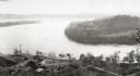
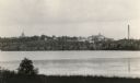
| Description: | River with distant hills behind a town. An island is in the foreground. |
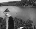
| Date: | 1948 |
|---|---|
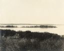
| Description: | View from the east bluff of lake with a motorboat. A geologic pinnacle juts out from the lower left of the image. |
| Date: | |
|---|---|
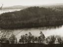
| Description: | Elevated view of the "mount" and the wide river before it and behind it. Houses and smokestacks can be seen in the far distance. |
| Date: | |
|---|---|
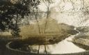
| Description: | Elevated view of a bow in the river, and a homestead on the shore, with a two-story house and a barn. Two wagons are close to the barn in the lower left co... |
| Date: | |
|---|---|
| Description: | View of the mill and the dam, and the river. The area around the mill is heavily forested. Caption reads: "Dells Paper Mill and Dam, Eau Claire, Wis." |
| Date: | |
|---|---|
| Description: | View across Lake Monona towards the Wisconsin State Capitol. |
| Date: | 1910 |
|---|---|
| Description: | Big spring on Lake Mendota Drive. [Merrill Springs or sometimes Merrill's Spring] |
| Date: | 1915 |
|---|---|
| Description: | The University of Wisconsin from Picnic Point. Buildings that can be seen are Bascom Hall with dome, the Students' Observatory, Washburn Observatory, the D... |

| Date: | 03 24 1913 |
|---|---|
| Description: | Picnic Point from the University Farm fields, now known as Observatory Hill. |
| Date: | |
|---|---|
| Description: | Picnic Point from Observatory Hill. |
If you didn't find the material you searched for, our Library Reference Staff can help.
Call our reference desk at 608-264-6535 or email us at: