 Filter: Categories of Wisconsin Historical Images
Filter: Subject of Forests and forestry
Filter: Subject of water
Filter: Subject of bird's-eye views
Filter: Categories of Wisconsin Historical Images
Filter: Subject of Forests and forestry
Filter: Subject of water
Filter: Subject of bird's-eye views

| Date: | 1883 |
|---|---|
| Description: | Bird's-eye map of Sauk City. |
| Date: | 1930 |
|---|---|
| Description: | View from hill of a farm near a pond. There are homes along the far shoreline, and a lake and hills in the far background. |

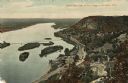
| Date: | |
|---|---|
| Description: | A bird's eye view overlooking the Mississippi River, sand bars, the railroad bridge, surrounding forests and wetlands. |
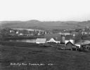
| Date: | 1910 |
|---|---|
| Description: | Color enhanced aerial view of the village of DeSoto, looking north along the Mississippi River. Caption reads: "Bird's Eye View of the Village of De Soto, ... |

| Date: | 1630 |
|---|---|
| Description: | One of the few maps by Dutch cartographer Willem Blaeu depicting the Americas, this map shows regions, settlements, islands, mountains, forests, rivers, an... |

| Date: | 1950 |
|---|---|
| Description: | Text on front reads: "Horseshoe Curve At Rock Springs, Wis." A road and a railroad track, with bridges over the Baraboo River, make a double curve in an el... |
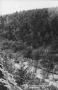
| Date: | 1950 |
|---|---|
| Description: | Text on front reads: "The Old Mill Stream in the Narrows at Rock Springs, Wis." A road and the Narrows Creek run next to each other in an elevated view of ... |
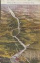
| Date: | 1910 |
|---|---|
| Description: | Text on front reads: "Dells of Wisconsin and Kilbourn City." An illustrated Bird's Eye View of the Dells area with 33 numbered features: "1 - High Rock, 2 ... |
If you didn't find the material you searched for, our Library Reference Staff can help.
Call our reference desk at 608-264-6535 or email us at: