 Filter: Categories of Wisconsin Historical Images
Filter: Subject of Forests and forestry
Filter: Subject of water
Filter: County of Bayfield
Filter: Categories of Wisconsin Historical Images
Filter: Subject of Forests and forestry
Filter: Subject of water
Filter: County of Bayfield
| Date: | |
|---|---|
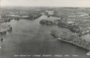
| Description: | Photographic postcard of an aerial view of Lake Owen near Cable. Most of the lake is located within the Chequamegon National Forest. Caption reads: "Air Vi... |

| Date: | |
|---|---|
| Description: | Color postcard of a view of a lake from a shoreline. A power boat and a fishing boat can be seen through the trees. "Cable, Wisc." is printed in red on the... |
| Date: | 1937 |
|---|---|
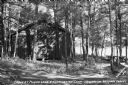
| Description: | View of a cabin and picnic table at Pigeon Lake Organization Camp in the Chequamegon National Forest. The cabin is surrounded by trees, and in the distance... |

| Date: | |
|---|---|
| Description: | Elevated view of the sun shining through clouds over a lake, identified as Lake Namakagon. In the foreground are trees, and more trees are visible on the o... |

| Date: | |
|---|---|
| Description: | View of the sun shining through clouds over Lake Namakagon. There are trees are visible on the opposite shorelines. Text describing the photograph says, "t... |

| Date: | |
|---|---|
| Description: | Elevated view of the sun shining through clouds over Lake Namakagon. In the foreground are a few trees and in the distance is the opposite shoreline. Text ... |

| Date: | |
|---|---|
| Description: | Scenic view of the sun through clouds over a lake, identified as Lake Namakagon. In the foreground is a pine tree, and across the lake the opposite shoreli... |

| Date: | |
|---|---|
| Description: | View of a dirt road, cleared land, Jackson Lake and shoreline. Off to the far right is where the Nature Lovers Paradise resort cottages were located. A sig... |

| Date: | |
|---|---|
| Description: | View of the sun shining through clouds over a lake, identified as Lake Namakagon. In the foreground are some rocks on the shoreline, and more trees are vis... |

| Date: | |
|---|---|
| Description: | View of the sun shining through clouds over a lake, either Jackson Lake or Lake Namakagan. In the foreground are some trees, and more trees are visible on ... |

| Date: | 1935 |
|---|---|
| Description: | This pictorial map of northern Bayfield County, Wisconsin, shows the Chequamegon National Forest, the Red Cliff Indian Reservation, highways and roads, and... |

| Date: | 1967 |
|---|---|
| Description: | This tourist brochure for Bayfield County, Wisconsin, from 1967 includes a map of the county showing towns, cities and villages, highways and roads, railro... |

| Date: | 1971 |
|---|---|
| Description: | A topgraphical map of Cable, Wisconsin showing railroads. |

| Date: | 1971 |
|---|---|
| Description: | A topographical map of Namekagon Lake and the surrounding area. |

| Date: | 1929 |
|---|---|
| Description: | Aerial view of Lake Namakagon, showing the roads that connect Anderson Island (center left), and Juneks Point, Eagle Point, and Paines Island. |

| Date: | |
|---|---|
| Description: | Aerial view of the Pike Chain of Lakes near Iron River, Wisconsin. Caption reads: "Pike Chain of Lakes." Text on back reads: "The ideal vacationland for fi... |

| Date: | 1971 |
|---|---|
| Description: | A topographical map of the Grand View NW quadrangle. |

| Date: | |
|---|---|
| Description: | Aerial view of the cow palace and pasture, the boathouse, and the Lake Namakagon shoreline. The main lodge is barely visible among trees. Old highway count... |

| Date: | 1935 |
|---|---|
| Description: | Slightly elevated view of three men cutting and loading ice into a dump truck on Namakagon Lake. One man is guiding ice blocks through open water to a conv... |
If you didn't find the material you searched for, our Library Reference Staff can help.
Call our reference desk at 608-264-6535 or email us at:
