Filter: Categories of Wisconsin Historical Images
Filter: Subject of Forests and forestry
Filter: Subject of water
Filter: Community of Madison
Filter: Categories of Wisconsin Historical Images
Filter: Subject of Forests and forestry
Filter: Subject of water
Filter: Community of Madison
| Date: | |
|---|---|
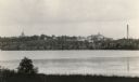
| Description: | View across Lake Monona towards the Wisconsin State Capitol. |
| Date: | 1910 |
|---|---|
| Description: | Big spring on Lake Mendota Drive. [Merrill Springs or sometimes Merrill's Spring] |
| Date: | 1915 |
|---|---|
| Description: | The University of Wisconsin from Picnic Point. Buildings that can be seen are Bascom Hall with dome, the Students' Observatory, Washburn Observatory, the D... |

| Date: | 03 24 1913 |
|---|---|
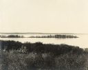
| Description: | Picnic Point from the University Farm fields, now known as Observatory Hill. |
| Date: | |
|---|---|
| Description: | Picnic Point from Observatory Hill. |
| Date: | |
|---|---|
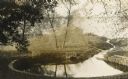
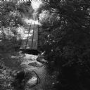
| Description: | Elevated view of a bridge. Trees are in the foreground, with Lake Mendota and the far shoreline in the distance. Original caption reads: "Rustic Bridge on ... |
| Date: | |
|---|---|
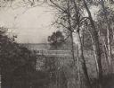
| Description: | Second Point in Maple Bluff looking toward Woodward's Grove. |

| Date: | |
|---|---|
| Description: | Picnic Point from Observatory Hill. |
| Date: | |
|---|---|
| Description: | Evening view of Capitol from across Lake Mendota. |

| Date: | 03 15 1896 |
|---|---|
| Description: | Winter view down Capitol Avenue, possibly in Maple Bluff. |

| Date: | 1930 |
|---|---|
| Description: | Aerial view of the University of Wisconsin-Madison Arboretum including a portion of Lake Wingra and surrounding residential neighborhoods. |

| Date: | 07 15 1958 |
|---|---|
| Description: | Aerial view of Eagle Heights Farm, Eagle Heights Woods and part of Lake Mendota. Sites labeled on the image are Eagle Heights, Tent Colony, Apartment Site,... |

| Date: | 1970 |
|---|---|
| Description: | Color coded map. Legend in the top left hand corner reads: "EXISTING AIRPORT PAVEMENT" (purple), "FUTURE 5-YEAR DEVELOPMENT" (bright pink), "ULTIMATE AIRPO... |
| Date: | 08 2013 |
|---|---|
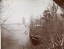
| Description: | View across rocks in a stream towards a board pathway that vanishes into the distance. Oak savanna in late summer. |

| Date: | 01 13 1937 |
|---|---|
| Description: | Sketch map of Township 7 North, Range 9 East, created for the Land Economic Inventory (Bordner Survey). The map shows Picnic Point and the Lake Mendota sho... |
If you didn't find the material you searched for, our Library Reference Staff can help.
Call our reference desk at 608-264-6535 or email us at: