 Filter: Categories of Wisconsin Historical Images
Filter: Subject of Forests and forestry
Filter: Subject of forest conservation
Filter: Categories of Wisconsin Historical Images
Filter: Subject of Forests and forestry
Filter: Subject of forest conservation
| Date: | |
|---|---|
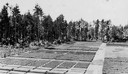
| Description: | Elevated view of a variety of evergreen trees in a nursery, including White, Norway, Scotch and Jack pines, and White and Norway spruce near Trout Lake. |
| Date: | |
|---|---|
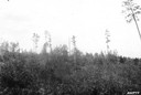
| Description: | Cutover Norway Pine lands showing character of restocking and scattered trees. |
| Date: | 1943 |
|---|---|
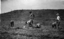
| Description: | Menominee women working to protect their white pines from blister rust. |

| Date: | 1936 |
|---|---|
| Description: | Loading a large white pine log cut on the Menominee Indian Reservation onto a truck. The log was hauled to the Wisconsin State Fair for a display about the... |
| Date: | 03 1938 |
|---|---|
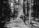
| Description: | A large white pine being felled on the Menominee Indian Reservation. This photograph was taken to illustrate the tribe's selective logging practices. |
| Date: | 1935 |
|---|---|
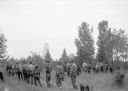
| Description: | Slightly elevated view of a ribes eradication crew that was part of the white pine blister rust effort in a Barron County forest. The caption indicates tha... |
| Date: | 1935 |
|---|---|
| Description: | Barracks buildings at the Crystal Lake Civilian Conservation Corps (CCC) camp. |
| Date: | 1938 |
|---|---|
| Description: | A crew of Civilian Conservation Corps (CCC) youth starting for the field where they were working on ribes eradication as part of the effort to defeat the w... |
| Date: | |
|---|---|
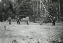
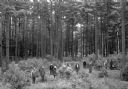
| Description: | Group of men and boys planting white pine seedlings. |
| Date: | |
|---|---|
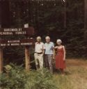
| Description: | Marker at the Uhrenholdt Memorial Forest established by farmer Soren J. Uhrenholdt on land that was part of northern Wisconsin's "Cutover Region." A leader... |

| Date: | 08 1922 |
|---|---|
| Description: | This Wisconsin State Conservation Commission map shows the distribution of standing timber per township. The northern tier of counties is covered, as are V... |

| Date: | 04 1932 |
|---|---|
| Description: | This Wisconsin Conservation Department map shows federal, state, and county forest areas, the relative proportion of land owned by each agency, and state p... |

| Date: | 05 1935 |
|---|---|
| Description: | This Wisconsin Conservation Department map shows the locations of state forests, state nurseries, state parks, roadside parks, prison camps, and lookout to... |

| Date: | 1935 |
|---|---|
| Description: | "Drott's conservation guide" map shows the locations of Indian reservations, parks, fish hatcheries, forests, lookout towers, Wisconsin Conservations Commi... |

| Date: | 1936 |
|---|---|
| Description: | This 1936 Wisconsin Conservation Dept. map shows the locations of state forestry Civilian Conservation Corps (CCC) camps, closed state forestry CCC camps, ... |

| Date: | 05 01 1938 |
|---|---|
| Description: | This map shows the locations of Wisconsin Conservation Department forest protection districts and cooperative areas, state forests, national forests, India... |

| Date: | |
|---|---|
| Description: | A building, surrounded in deep snow, used by Wisconsin forest rangers of district 8, perhaps in northern Wisconsin. The building includes two sets of close... |

| Date: | 1912 |
|---|---|
| Description: | Group portrait of twelve men posing on the steps and porch of a building, probably forest rangers. The men are wearing a variety of clothing, including a b... |

| Date: | 12 01 1911 |
|---|---|
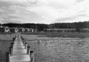
| Description: | An elevated view from hill of Pokegama Camp at Spider Lake. Caption reads: "Pokegama Camp, Spider Lake, Mercer, Wis." |

| Date: | 1950 |
|---|---|
| Description: | Wisconsin Historical Marker near Trout Lake. The marker recognizes the first ever forest patrol flight. The marker text reads: "FIRST FOREST PATROL FLI... |
If you didn't find the material you searched for, our Library Reference Staff can help.
Call our reference desk at 608-264-6535 or email us at: