 Filter: Categories of Wisconsin Historical Images
Filter: Subject of Forests and forestry
Filter: Subject of electric power
Filter: Categories of Wisconsin Historical Images
Filter: Subject of Forests and forestry
Filter: Subject of electric power

| Date: | |
|---|---|
| Description: | View of the circle swing at Waldemeer Park. The ride is surrounded by a fence, trees, and several power lines. |
| Date: | |
|---|---|
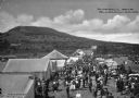
| Description: | People walking around tents at the Bluehill Fair. A road stands to the right and hills are visible in the background. |
| Date: | |
|---|---|
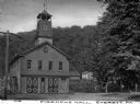
| Description: | Front view of the multi-story brick Fireman's Hall. A tower with a lookout at the top extends from the roof. A forested hill and dwellings appear in the ... |
| Date: | |
|---|---|
| Description: | Cars travel past dwellings and power lines along a country road. |

| Date: | 1905 |
|---|---|
| Description: | A man wearing a suit and hat is standing in a roadway through "the narrows." In the background is a steep ridge. Also in the background are stacks of wood ... |

| Date: | 1970 |
|---|---|
| Description: | This map shows colored-coded land use with a legend in the bottom margin. Land classifications include: Year-round Residential (yellow), Seasonal Residenti... |
If you didn't find the material you searched for, our Library Reference Staff can help.
Call our reference desk at 608-264-6535 or email us at: