 Filter: Categories of Wisconsin Historical Images
Filter: Subject of Forests and forestry
Filter: County of Sauk
Filter: Categories of Wisconsin Historical Images
Filter: Subject of Forests and forestry
Filter: County of Sauk

| Date: | 1896 |
|---|---|
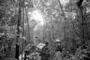
| Description: | View along shoreline of the Wisconsin River, with a sandy beach leading to a stand of trees on the bank on the right. Buildings are along the opposite bank... |
| Date: | 06 26 1957 |
|---|---|
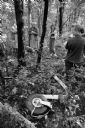
| Description: | Sauk County Deputy Melvin Albers points out the direction that the light plane took as it crashed through a forest near Baraboo, taking the lives of Louis ... |
| Date: | 06 26 1957 |
|---|---|
| Description: | Area residents check the wreckage of the plane near LaRue, about 15 miles west of Baraboo. Mrs. Ed Meyer (standing between the two trees with folded hands)... |

| Date: | 06 04 1961 |
|---|---|
| Description: | View across a field, with a gently sloping hill to the left, and hills and forests in the distance. Caption reads: "Denzer (vicinity), Wis. June 4, 1961. F... |

| Date: | 1950 |
|---|---|
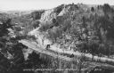
| Description: | Text on front reads: "Horseshoe Curve At Rock Springs, Wis." A road and a railroad track, with bridges over the Baraboo River, make a double curve in an el... |
| Date: | 1950 |
|---|---|
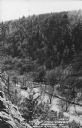
| Description: | Text on front reads: "Upper Narrows, Rock Springs, Wis." A road and a railroad tracks run next to each other in an elevated view of the Upper Narrows. Text... |
| Date: | 1950 |
|---|---|
| Description: | Text on front reads: "The Old Mill Stream in the Narrows at Rock Springs, Wis." A road and the Narrows Creek run next to each other in an elevated view of ... |
If you didn't find the material you searched for, our Library Reference Staff can help.
Call our reference desk at 608-264-6535 or email us at: