 Filter: Categories of Wisconsin Historical Images
Filter: Subject of Forests and forestry
Filter: County of Sauk
Filter: Subject of transportation
Filter: Categories of Wisconsin Historical Images
Filter: Subject of Forests and forestry
Filter: County of Sauk
Filter: Subject of transportation

| Date: | 1883 |
|---|---|
| Description: | Bird's-eye map of Sauk City. |
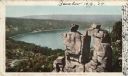
| Date: | 1948 |
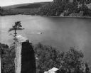
|---|---|
| Description: | View from the east bluff of lake with a motorboat. A geologic pinnacle juts out from the lower left of the image. |
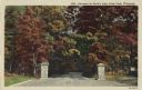
| Date: | 1946 |
|---|---|
| Description: | Colorized postcard of the entrance to Devil's Lake State Park. Trees and foliage fill the scene and it appears to be autumn. Stone pillars are on either si... |
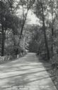
| Date: | |
|---|---|
| Description: | Photographic postcard of the Warner Memorial Road in Devil's Lake State Park. Trees line both sides of the road, and there is a stone wall on the left. The... |
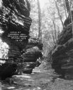
| Date: | 1925 |
|---|---|
| Description: | Rock formations at Congress Hall on the Dell View Resort property. |

| Date: | 1921 |
|---|---|
| Description: | A high wooden pedestrian bridge along a forest path, crossing over a deep gorge. |
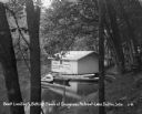
| Date: | 1931 |
|---|---|
| Description: | A boathouse and canoe boats along Lake Delton. The boathouse is painted with advertisements that read, "Cottages - Rooms - Cabins - Refreshments - Free Cam... |

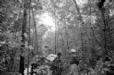
| Date: | |
|---|---|
| Description: | View down trail along steep hill in the woods with birch and pine trees. A sign posted on a tree reads: "To The Cave." |
| Date: | 1898 |
|---|---|
| Description: | Colorized postcard view of the Devil's Doorway rock formation overlooking Devil's Lake. Caption reads: "Devil's Doorway, Devil's Lake, Wis." |
| Date: | 06 26 1957 |
|---|---|
| Description: | Sauk County Deputy Melvin Albers points out the direction that the light plane took as it crashed through a forest near Baraboo, taking the lives of Louis ... |
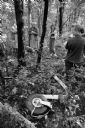
| Date: | 06 26 1957 |
|---|---|
| Description: | Area residents check the wreckage of the plane near LaRue, about 15 miles west of Baraboo. Mrs. Ed Meyer (standing between the two trees with folded hands)... |

| Date: | 1950 |
|---|---|
| Description: | Text on front reads: "Horseshoe Curve At Rock Springs, Wis." A road and a railroad track, with bridges over the Baraboo River, make a double curve in an el... |
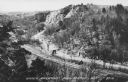
| Date: | 1950 |
|---|---|
| Description: | Text on front reads: "Upper Narrows, Rock Springs, Wis." A road and a railroad tracks run next to each other in an elevated view of the Upper Narrows. Text... |
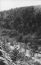
| Date: | 1950 |
|---|---|
| Description: | Text on front reads: "The Old Mill Stream in the Narrows at Rock Springs, Wis." A road and the Narrows Creek run next to each other in an elevated view of ... |
If you didn't find the material you searched for, our Library Reference Staff can help.
Call our reference desk at 608-264-6535 or email us at: