 Filter: Categories of Wisconsin Historical Images
Filter: Subject of Forests and forestry
Filter: Creator Name of Wisconsin. Conservation Department.
Filter: Subject of land
Filter: Categories of Wisconsin Historical Images
Filter: Subject of Forests and forestry
Filter: Creator Name of Wisconsin. Conservation Department.
Filter: Subject of land
| Date: | |
|---|---|
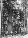
| Description: | Three men are sitting at the base of a large tree at Flambeau State Forest. |
| Date: | 1948 |
|---|---|
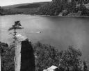
| Description: | View from the east bluff of lake with a motorboat. A geologic pinnacle juts out from the lower left of the image. |

| Date: | 1930 |
|---|---|
| Description: | A view looking west at Rib Mountain across the Wisconsin River from the outskirts of Wausau. |

| Date: | 1958 |
|---|---|
| Description: | Includes images of Flambeau River State Forest and a description of, canoeing and recreational activities in, and general park and forest information about... |

| Date: | 04 1932 |
|---|---|
| Description: | This Wisconsin Conservation Department map shows federal, state, and county forest areas, the relative proportion of land owned by each agency, and state p... |

| Date: | 1936 |
|---|---|
| Description: | This 1936 Wisconsin Conservation Dept. map shows the locations of state forestry Civilian Conservation Corps (CCC) camps, closed state forestry CCC camps, ... |

| Date: | 1956 |
|---|---|
| Description: | This map shows the types of upland and lowland forest vegetation on Stockton Island, one of the Apostle Islands in Lake Superior. |

| Date: | |
|---|---|
| Description: | View of a forest fire taken from an adjoining field. A fence separates the field from the burning trees. |

| Date: | |
|---|---|
| Description: | View down dirt road through cut-over and burned-over terrain. |
| Date: | |
|---|---|
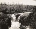
| Description: | Elevated view of Copper Falls on the Bad River. Four people, one man and three women, are posing on rocks at the top of the falls. Surrounding burned-over ... |

| Date: | 1930 |
|---|---|
| Description: | Small group of women with a leader in wooded area on a trail engaged in nature study. |

| Date: | |
|---|---|
| Description: | Back of card reads: "One of the Everglade appearing sloughs running along for miles parallel with the Lake Michigan shore — This view seen from the park ... |
| Date: | 1954 |
|---|---|
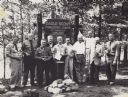
| Description: | Ten men are standing in a row in front of a sign marking the 25th anniversary of the Eagle Scout Forestry Camp. They are each holding an Eagle Scout trophy... |

| Date: | 1958 |
|---|---|
| Description: | This map shows state public hunting and/or fishing grounds, national forests, state forests, county forests.The lower margin includes an index to these loc... |

| Date: | 1950 |
|---|---|
| Description: | A young woman is posing sitting on a boulder on the shoreline along a river rapids. She is holding a walking stick and is wearing a romper. The description... |
If you didn't find the material you searched for, our Library Reference Staff can help.
Call our reference desk at 608-264-6535 or email us at: