Filter: Categories of Wisconsin Historical Images
Filter: Subject of Forests and forestry
Filter: Creator Name of Geological Survey
Filter: Categories of Wisconsin Historical Images
Filter: Subject of Forests and forestry
Filter: Creator Name of Geological Survey

| Date: | 1971 |
|---|---|
| Description: | A topgraphical map of Cable, Wisconsin showing railroads. |

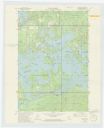
| Date: | 1971 |
|---|---|
| Description: | A topographical map of Namekagon Lake and the surrounding area. |

| Date: | 1972 |
|---|---|
| Description: | A topographic map of the Blackwell quadrangle. |

| Date: | 1971 |
|---|---|
| Description: | A topographical map of the Grand View NW quadrangle. |
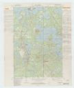
| Date: | 1982 |
|---|---|
| Description: | A map of the Hazelhurst quadrangle annotated with railroad information. |
If you didn't find the material you searched for, our Library Reference Staff can help.
Call our reference desk at 608-264-6535 or email us at: