 Filter: Categories of Wisconsin Historical Images
Filter: Subject of Forests and forestry
Filter: Creator Name of Foster, Mary Stuart
Filter: Categories of Wisconsin Historical Images
Filter: Subject of Forests and forestry
Filter: Creator Name of Foster, Mary Stuart

| Date: | 1935 |
|---|---|
| Description: | This map shows Wisconsin’s pinery region. Lake Superior, Lake Michigan, Lake Winnebago, Green Bay, the Wisconsin River, and the Mississippi River are label... |
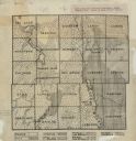
| Date: | 1922 |
|---|---|
| Description: | This early 20th century manuscript map shows prairie, maple, maple and beech, marsh conifer, oak, oak and maple, and grass and sedge areas by town in Dodge... |
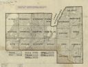
| Date: | 1930 |
|---|---|
| Description: | Map shows prairie, oak, maple, oak and maple, marsh conifer, maple and beech, and grass and sedge. |
If you didn't find the material you searched for, our Library Reference Staff can help.
Call our reference desk at 608-264-6535 or email us at: