 Filter: Categories of Wisconsin Historical Images
Filter: Subject of Foreign Languages
Filter: Subject of persons
Filter: Type of Map or Atlas
Filter: Categories of Wisconsin Historical Images
Filter: Subject of Foreign Languages
Filter: Subject of persons
Filter: Type of Map or Atlas
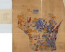
| Date: | 1890 |
|---|---|
| Description: | A hand-colored map of Wisconsin showing distribution ethnic groups based on the 1885 state census. The various nationalities are color-coded and include: I... |

| Date: | 1720 |
|---|---|
| Description: | Double hemispherical world map showing routes of Tasman, Magellan, Mendana, etc. Relief shown pictorially. Title in oak wreath cartouche. Map between four ... |
If you didn't find the material you searched for, our Library Reference Staff can help.
Call our reference desk at 608-264-6535 or email us at: