 Filter: Categories of Wisconsin Historical Images
Filter: Subject of Food industry and trade
Filter: Year of 1800-1899
Filter: Categories of Wisconsin Historical Images
Filter: Subject of Food industry and trade
Filter: Year of 1800-1899
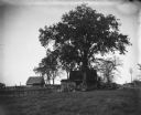
| Date: | 05 1899 |
|---|---|
| Description: | View of William Krueger's house across the road from the Krueger farm. |

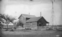
| Date: | 1895 |
|---|---|
| Description: | A card depicting two men posed near a stringer holding the many fish they caught. The caption reads, "Result of a day's fishing on Elk River, Price Co." |
| Date: | 08 02 1895 |
|---|---|
| Description: | Ephraim Watt, his wife Rhoda Adelaide Watt (née Mosher), and their daughter, Glendora Eunice Watt, pose in front of their log home, 14 miles southwest of F... |
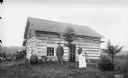
| Date: | 08 01 1895 |
|---|---|
| Description: | Men posing in Albert Smith's three-acre cornfield. Two men stand near the fence, and three others are in the background holding up their hats. |
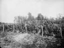
| Date: | 1895 |
|---|---|
| Description: | Exterior of the Joseph Steinwand Cheese Factory, with a windmill and scrap lumber scattered along the fence. |
| Date: | 1885 |
|---|---|
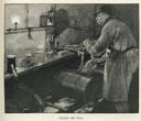
| Description: | Engraved image of a man wearing an apron and a hat and filling a keg with beer from a tap. |
| Date: | 1885 |
|---|---|
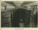
| Description: | Engraved image of two men working in a cellar full of wooden barrels filled with fermenting beer. |
| Date: | 1885 |
|---|---|
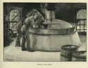
| Description: | Engraved image of a man adding ingredients from a barrel to a boiling vat of beer. |
| Date: | 1880 |
|---|---|
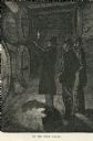
| Description: | Engraved image of three men in a dark room examining kegs of beer by candlelight. |

| Date: | 1896 |
|---|---|
| Description: | A hand-colored Map of Jefferson County, Wisconsin, shows township and section divisions, towns, villages and post offices, rural residents, railroads, road... |

| Date: | 1871 |
|---|---|
| Description: | This map of Barron County, Wisconsin, shows the township and range grid, towns, sections, cities and villages, post offices, dwellings, schools, roads, swa... |

| Date: | 1896 |
|---|---|
| Description: | This late 19th century map of Walworth County, Wisconsin, shows the township and range grid, towns, sections, villages and post offices, roads, railroads, ... |

| Date: | 1870 |
|---|---|
| Description: | This 1870 map of Brown County, Wisconsin, shows the township and range grid, towns, sections, cities, villages and post offices, land ownership, roads, rai... |

| Date: | 1858 |
|---|---|
| Description: | Map showing roads, mills, and rivers. Date conjectured from presence of Ensign’s Mill and Pitt’s Mill and location of Nekoosa. |

| Date: | 1842 |
|---|---|
| Description: | Relief shown by hachures. Shows furnaces, saw mills, houses, roads, grist mills, entries, reservations, and diggings. "Compiled by order of the Board of C... |

| Date: | 1889 |
|---|---|
| Description: | Bird’s-eye-view map. Published in the Milwaukee Sentinel: Wednesday morning, August 28, 1889 for the 23rd National Encampments of the GAR, August 27... |
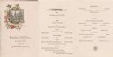
| Date: | 04 06 1884 |
|---|---|
| Description: | Front cover and menu of the restaurant at the Park Hotel, with an etching of a building with a steeple amidst many trees set against a circular frame ornam... |
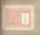
| Date: | 09 1887 |
|---|---|
| Description: | Lunch menu from the souvenir booklet of the Complimentary Excursion to General Passenger & Ticket Agents, with an embossed illustration of a spider in her ... |
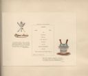
| Date: | 09 1887 |
|---|---|
| Description: | Lunch menu from the souvenir booklet of the Complimentary Excursion to General Passenger & Ticket Agents, with an embossed knife, fork, and spoon crossed o... |
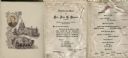
| Date: | 03 05 1891 |
|---|---|
| Description: | Front cover and inside of menu for a dinner honoring U.S. Senator John C. Spooner when he was Chairman of the Committee on Claims, with an oval photograph ... |
If you didn't find the material you searched for, our Library Reference Staff can help.
Call our reference desk at 608-264-6535 or email us at: