 Filter: Categories of Wisconsin Historical Images
Filter: Subject of Food industry and trade
Filter: Subject of superior, lake
Filter: Categories of Wisconsin Historical Images
Filter: Subject of Food industry and trade
Filter: Subject of superior, lake
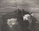
| Date: | 1955 |
|---|---|
| Description: | Three fisherman in a boat pulling in a net full of fish on Chequamegon Bay while a man and a boy look on. |

| Date: | 1937 |
|---|---|
| Description: | This Wisconsin Conservation Department map shows the locations of game refuges, fish hatcheries, canning factories, fish camps, and fish refuges in the sta... |

| Date: | 1906 |
|---|---|
| Description: | A commercial map of Wisconsin showing the location of creameries and cheese factories in the state. In the lower portion of the map provides the number of ... |
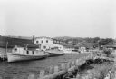
| Date: | |
|---|---|
| Description: | Photographic postcard of an elevated view of the fishery and its dock. Caption reads: "View of Booth Fisheries Dock." |
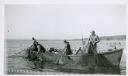
| Date: | |
|---|---|
| Description: | Four fishermen in a boat lift nets on Lake Superior. The far shoreline is in the background. |

| Date: | |
|---|---|
| Description: | Exterior of the menu for Paul's Cafe, with a bird's-eye view map of "Washburn's Natural Deep Water Land Locked Harbor," Chequamegon Bay, and the Apostle Is... |

| Date: | 1923 |
|---|---|
| Description: | This map includes an explanation that reads: "This chart shows the movement of corn on the Great Lakes, St. Lawrence River, and New York State Barge Canal ... |

| Date: | 1851 |
|---|---|
| Description: | This map shows townships, villages, Indian villages, railroads, roads, mills, prairies, swamps, and canals. An inset map shows a plat of the copper distric... |
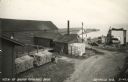
| Date: | 07 1936 |
|---|---|
| Description: | Fishing tugs are moored alongside the wharf at Bayfield. The large Bayfield Fish Co. building is identified in large letters on the end of the building. Th... |
If you didn't find the material you searched for, our Library Reference Staff can help.
Call our reference desk at 608-264-6535 or email us at: