Filter: Categories of Wisconsin Historical Images
Filter: Subject of Food industry and trade
Filter: Subject of rivers
Filter: Categories of Wisconsin Historical Images
Filter: Subject of Food industry and trade
Filter: Subject of rivers
| Date: | |
|---|---|
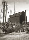
| Description: | View of old sailing boats at a shoreline with elevator A in the background. |
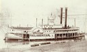
| Date: | 03 1866 |
|---|---|
| Description: | The sidewheel excursion, Phil Sheridan, at Wheeling, West Virginia in March, 1866. Sign on side of boat reads: "Cincinnati and Wheeling Packet, Phil... |
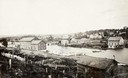
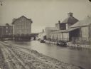
| Date: | |
|---|---|
| Description: | View across water towards Best's South Side Brewery. There are railroad cars in front of the brewery. |
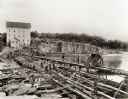
| Date: | |
|---|---|
| Description: | Men working on the dam at Munger's Mill. |
| Date: | |
|---|---|
| Description: | Several men on a raft going over the dam at Munger's Mill. There is a railroad bridge in the background. |

| Date: | 02 21 1874 |
|---|---|
| Description: | African American boatmen run a rapids in a small river boat. |
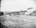
| Date: | 1904 |
|---|---|
| Description: | View across Yahara River towards a group of people on the Sherman Avenue Bridge, with the old malt house in the background. |

| Date: | 1898 |
|---|---|
| Description: | Bird's-eye map of Milwaukee with prominent streets and buildings identified. Taken from City Hall Tower. |

| Date: | 1882 |
|---|---|
| Description: | This map of Cedarburg is a bird's-eye map with an inset of Cedarburg Brewery. Relief is shown pictorially and the map includes an index to buildings. |

| Date: | 2007 |
|---|---|
| Description: | This map of Cedarbug is a bird's-eye map with 8 inset views and an index. The map is a print out of the original map dated 1892 held at the Cedarburg Cultu... |

| Date: | 1878 |
|---|---|
| Description: | Bird's-eye map of Chilton with insets of points of interest, including P.H. Becker's Brewery, Chilton House, and Gutheil's Block. |
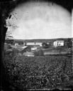
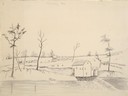
| Date: | 1875 |
|---|---|
| Description: | View, through a cornfield, of people, a store, a sawmill and wagons. Moscow was platted in 1850 by an Englishman, Chauncy Smith, who dammed the Bluemound ... |
| Date: | 1868 |
|---|---|
| Description: | View of the Baraboo River and surrounding structures. |
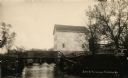
| Date: | 1914 |
|---|---|
| Description: | View of a mill on the bank of a river, and an adjacent dam. Caption at bottom reads: "Scene At Picturesque Friendship, Wis." |
| Date: | 05 17 1849 |
|---|---|
| Description: | The Mill in Nodaway, Missouri; Sketched by Wilkins on his 151-day journey from Missouri to California on the Overland Trail (also known as the Oregon Trail... |
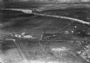
| Date: | 1934 |
|---|---|
| Description: | Aerial view of the Jones dairy farm, Fort Atkinson, in winter. The Rock River is in the background. |
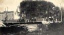
| Date: | |
|---|---|
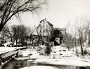
| Description: | Farwell's Mill on the Yahara River at Lake Mendota. |

| Date: | 1853 |
|---|---|
| Description: | Farwell's Mill on the Yahara River at Lake Mendota. |
If you didn't find the material you searched for, our Library Reference Staff can help.
Call our reference desk at 608-264-6535 or email us at: