 Filter: Categories of Wisconsin Historical Images
Filter: Subject of Food industry and trade
Filter: Subject of maps
Filter: Categories of Wisconsin Historical Images
Filter: Subject of Food industry and trade
Filter: Subject of maps
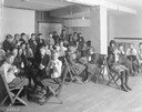
| Date: | 1921 |
|---|---|
| Description: | Classroom full of school children drinking milk at Washington school. |
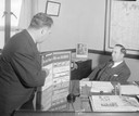
| Date: | 10 03 1944 |
|---|---|
| Description: | Mr. Rose showing Clyde S. Tutton a Lord Calvert whiskey educational display in the Wisconsin Treasury Department, Beverage and Cigarette Tax Division offic... |
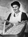
| Date: | 11 15 1963 |
|---|---|
| Description: | Pastry maker removes oil with baster from pan of baked baklava against the backdrop of a map of Armenia. |

| Date: | |
|---|---|
| Description: | Wisconsin promotional decal with a map of the state, with many cities marked and drawings of some Wisconsin icons: cheese, cows, deer, beer, Wisconsin Dell... |
| Date: | 1950 |
|---|---|
| Description: | Agricultural exhibit designed by the Wisconsin State Cranberry Growers Association and Eatmor Cranberries. The exhibit shows various types and stages of cr... |
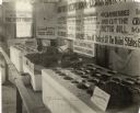
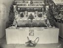
| Date: | 1915 |
|---|---|
| Description: | Exhibit at the Milwaukee County Fair devoted to Wisconsin's cranberry production. The exhibit includes cranberry plants, various cranberry varieties, cranb... |

| Date: | |
|---|---|
| Description: | Capital Island Wheat beer label. The label features a drawing of the Wisconsin Capitol dome flanked by stalks of wheat. There is also a map of Washington I... |

| Date: | 1952 |
|---|---|
| Description: | Map of the barley-growing regions of North America, published by the Rahr Malting Company, Manitowoc, Wisconsin, 1952. |

| Date: | |
|---|---|
| Description: | Back, front, and inside front cover of the menu from The Restaurant at Baron's department store, with "A Historical Map of Madison" focusing on the isthmus... |

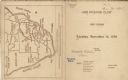
| Date: | |
|---|---|
| Description: | Map and advertisement for the Casa del Norte Tea Rooms, with a grid of several blocks in downtown Duluth highlighting the tea rooms as well as other notabl... |
| Date: | 11 14 1899 |
|---|---|
| Description: | Front and back covers of the first dinner of the Six O'Clock Club held at the Park Hotel, with a map on the back cover of the southern tip of Africa, with ... |
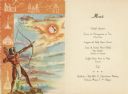
| Date: | 1952 |
|---|---|
| Description: | Front cover and menu page for a banquet given by the Instituto Mexicano del Seguro Social to the senior delegates to the fourth reunion of the Inter-Americ... |

| Date: | |
|---|---|
| Description: | Front and back covers of the Mortons Surf Club menu, with a black on blue grid of Chicago streets from Lake Michigan to Vincennes Avenue, and E. 45th to E.... |

| Date: | 1953 |
|---|---|
| Description: | Front and back of one-page menu from the Scandia Restaurant, with a whimsical cartoon map rendering by Hakon Mielche of the Scandinavian countries and the ... |

| Date: | 07 21 1951 |
|---|---|
| Description: | Luncheon menu for the S.S. Argentina, with a map of Argentina with spot illustrations for the provinces and featured products or symbols, the coat o... |

| Date: | |
|---|---|
| Description: | Exterior of the menu for Paul's Cafe, with a bird's-eye view map of "Washburn's Natural Deep Water Land Locked Harbor," Chequamegon Bay, and the Apostle Is... |
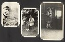
| Date: | |
|---|---|
| Description: | Page from Joy Camps photo album displaying three photographs. In one photograph Barbara Ellen Joy, camp owner and co-director, cooks over a large grill are... |

| Date: | 01 25 1964 |
|---|---|
| Description: | Oscar G. Mayer Jr., president of the Oscar Mayer Company, at a podium on the stage of the Orpheum Theatre. On the screen is a large map of United States wi... |

| Date: | 1896 |
|---|---|
| Description: | Front cover and interior of banquet menu for Mexican President Porfirio Diaz, to celebrate the construction of a drainage canal between Lake Texcoco and La... |

| Date: | 1715 |
|---|---|
| Description: | One of Herman Moll's most famous maps, often referred to as The Codfish Map, it shows rivers and portages, cities, Indian villages, wind directions, routes... |
If you didn't find the material you searched for, our Library Reference Staff can help.
Call our reference desk at 608-264-6535 or email us at: