 Filter: Categories of Wisconsin Historical Images
Filter: Subject of Food industry and trade
Filter: Subject of landforms
Filter: Categories of Wisconsin Historical Images
Filter: Subject of Food industry and trade
Filter: Subject of landforms

| Date: | 1878 |
|---|---|
| Description: | Bird's-eye map of Chilton with insets of points of interest, including P.H. Becker's Brewery, Chilton House, and Gutheil's Block. |

| Date: | 1880 |
|---|---|
| Description: | Bird's-eye map over the Mississippi River of Fountain City. Paddle steamers and steamboats are on the river, and bluffs are in the background. |

| Date: | 1871 |
|---|---|
| Description: | Birds eye map of Monroe, WI, depicts street names and street locations, houses, and trees. A reference key at the bottom of the map shows the locations of ... |
| Date: | 1895 |
|---|---|
| Description: | Buildings and grounds of the Leinenkugel Brewery. There are beer wagons in the yard, chickens along a wooden walkway, and men on a horse-drawn wagon near a... |

| Date: | |
|---|---|
| Description: | Two men posing on bluffs overlooking the Mississippi River at Fountain City. Fountain Brewery is visible at bottom right. |

| Date: | 1900 |
|---|---|
| Description: | Elevated view of the brewery dwarfed by the overhead bluffs. The brewery was built by William Schmitz. George Scheibl ran the brewery from 1899 until his d... |

| Date: | 1895 |
|---|---|
| Description: | View of a mill, sluice and dam on Waumandee Creek. The mill was built by John Oschner in 1863. Two products produced by the mill were White Rose Flour and ... |
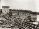
| Date: | 1895 |
|---|---|
| Description: | Munger's Mill and dam, with men standing on and around the dam. |

| Date: | 1935 |
|---|---|
| Description: | A student at Highlander having a picnic behind the school. |

| Date: | |
|---|---|
| Description: | View across wooden bridge to building identified as the Hixton Mill and Starch Factory on the edge of a body of water, probably a river. In the background ... |
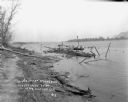
| Date: | 05 25 1910 |
|---|---|
| Description: | A man stands on the wreckage of a burned steamer in the Mississippi River near the shoreline. There is a small boat and a barrel nearby. Bluffs are in the ... |
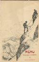
| Date: | 07 03 1908 |
|---|---|
| Description: | Folded menu from the Hotel Müller, with hikers on the die cut flap, ascending a mountain, and mountains and sky on the panel beneath. The drawings are sign... |

| Date: | 09 04 1885 |
|---|---|
| Description: | Exterior and interior bill of fare from The Chequamegon, with views on the back of rock formations, waterfalls, a spot illustration of a train going over a... |

| Date: | 1785 |
|---|---|
| Description: | Map of part of North America engraved and hand-colored (the light brown design is a superposition of the map and cartouche derived from the oxidation of th... |

| Date: | |
|---|---|
| Description: | Exterior of the menu for Paul's Cafe, with a bird's-eye view map of "Washburn's Natural Deep Water Land Locked Harbor," Chequamegon Bay, and the Apostle Is... |
If you didn't find the material you searched for, our Library Reference Staff can help.
Call our reference desk at 608-264-6535 or email us at: