 Filter: Categories of Wisconsin Historical Images
Filter: Subject of Food industry and trade
Filter: County of Price
Filter: Subject of cities and towns
Filter: Categories of Wisconsin Historical Images
Filter: Subject of Food industry and trade
Filter: County of Price
Filter: Subject of cities and towns
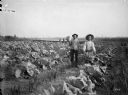
| Date: | 09 04 1895 |
|---|---|
| Description: | Men displaying produce, a large cabbage and a bushel of potatoes, while standing in the gardens of the Thayer farm. Cabbage, onion, currant, and raspberry ... |

| Date: | 1914 |
|---|---|
| Description: | This 1914 map of Price County, Wisconsin, shows land for sale by the Good Land Company and Dewitt van Ostrand of Phillips. Also shown are the township and ... |

| Date: | 1925 |
|---|---|
| Description: | This map of Price County, Wisconsin, from the early 20th century shows the township and range system, towns, sections, cities and villages, railroads, high... |
If you didn't find the material you searched for, our Library Reference Staff can help.
Call our reference desk at 608-264-6535 or email us at: