 Filter: Categories of Wisconsin Historical Images
Filter: Subject of Food industry and trade
Filter: County of Clark
Filter: Categories of Wisconsin Historical Images
Filter: Subject of Food industry and trade
Filter: County of Clark

| Date: | 1910 |
|---|---|
| Description: | "There never was but one Crop of Land. There never will be another." Shows towns, boundaries, roads, schoolhouses, sawmills, cheese factories, and creameri... |

| Date: | 1905 |
|---|---|
| Description: | View from river toward the bridge and mill. Caption reads: "Hewitt Street Bridge and Roller Mill on Oneill Creek, Neillsville, Wis." |
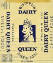
| Date: | 09 06 1944 |
|---|---|
| Description: | Label submitted to the State of Wisconsin for trademark registration. Features an image of a woman wearing a crown. Label is in blue with a cream backgroun... |

| Date: | |
|---|---|
| Description: | Letterhead of Blue Moon Foods, Inc., of Thorp, Wisconsin, with a border of waves, a blue sailboat, and a blue moon, and a wheel of Gold-N-Rich cheese, and ... |
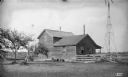
| Date: | 1895 |
|---|---|
| Description: | Exterior of the Joseph Steinwand Cheese Factory, with a windmill and scrap lumber scattered along the fence. |

| Date: | 1914 |
|---|---|
| Description: | This early-20th century map of Clark County, Wisconsin, shows the township and range grid, sections, cities and villages, wagon roads, railroads, settlers,... |
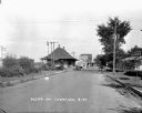
| Date: | 1927 |
|---|---|
| Description: | A street scene with the train depot on the left. An automobile parked on the street side. A seed store on the next block with someone entering it. There is... |

| Date: | 1976 |
|---|---|
| Description: | Wisconsin Congressman David R. Obey chats with a constituent manning the dairy bar as part of a campaign shoot. |
If you didn't find the material you searched for, our Library Reference Staff can help.
Call our reference desk at 608-264-6535 or email us at: