 Filter: Categories of Wisconsin Historical Images
Filter: Subject of Food industry and trade
Filter: Type of Map or Atlas
Filter: Categories of Wisconsin Historical Images
Filter: Subject of Food industry and trade
Filter: Type of Map or Atlas

| Date: | 1898 |
|---|---|
| Description: | Bird's-eye map of Milwaukee with prominent streets and buildings identified. Taken from City Hall Tower. |

| Date: | 1882 |
|---|---|
| Description: | This map of Cedarburg is a bird's-eye map with an inset of Cedarburg Brewery. Relief is shown pictorially and the map includes an index to buildings. |

| Date: | 2007 |
|---|---|
| Description: | This map of Cedarbug is a bird's-eye map with 8 inset views and an index. The map is a print out of the original map dated 1892 held at the Cedarburg Cultu... |

| Date: | 1878 |
|---|---|
| Description: | Bird's-eye map of Chilton with insets of points of interest, including P.H. Becker's Brewery, Chilton House, and Gutheil's Block. |

| Date: | 1880 |
|---|---|
| Description: | Bird's-eye map over the Mississippi River of Fountain City. Paddle steamers and steamboats are on the river, and bluffs are in the background. |

| Date: | 1871 |
|---|---|
| Description: | Birds eye map of Monroe, WI, depicts street names and street locations, houses, and trees. A reference key at the bottom of the map shows the locations of ... |

| Date: | 1918 |
|---|---|
| Description: | Map illlustrates creameries, condenseries and cheese factories in Wisconsin, January, 1918, and value of products. Five smaller maps in margin show changes... |

| Date: | 1910 |
|---|---|
| Description: | "There never was but one Crop of Land. There never will be another." Shows towns, boundaries, roads, schoolhouses, sawmills, cheese factories, and creameri... |
| Date: | 1884 |
|---|---|
| Description: | Sanborn map showing the main street of Potosi, Wisconsin, with an inset for the Potosi Brewery. |

| Date: | 1912 |
|---|---|
| Description: | Sanborn insurance map of the main street in Potosi, Wisconsin, with an inset for the Potosi Brewery. |

| Date: | 1949 |
|---|---|
| Description: | This color map includes historical descriptions of select areas and a short article on the history of Wisconsin. The major highways in the state shown on t... |

| Date: | 1835 |
|---|---|
| Description: | Ink on tracing paper map of Green Bay, Wisconsin and nearby areas, Lake Winnebago, Fox and Wolf Rivers, and the junctions of the Mississippi and Wisconsin ... |

| Date: | 1937 |
|---|---|
| Description: | This Wisconsin Conservation Department map shows the locations of game refuges, fish hatcheries, canning factories, fish camps, and fish refuges in the sta... |

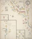
| Date: | 09 1884 |
|---|---|
| Description: | Sanborn map of Fort Atkinson including Barrie, Germany, and North Water Streets. |

| Date: | 1906 |
|---|---|
| Description: | A commercial map of Wisconsin showing the location of creameries and cheese factories in the state. In the lower portion of the map provides the number of ... |

| Date: | 1896 |
|---|---|
| Description: | A hand-colored Map of Jefferson County, Wisconsin, shows township and section divisions, towns, villages and post offices, rural residents, railroads, road... |

| Date: | 1909 |
|---|---|
| Description: | A map of Langlade County, Wisconsin that shows townships and ranges, towns, cities and villages, wagon roads, churches, schools, sawmills, town halls, chee... |

| Date: | 1915 |
|---|---|
| Description: | This 1915 map of Lincoln County, Wisconsin, shows the township and range grid, towns, cities and villages, lakes and streams, residences, churches, school ... |
If you didn't find the material you searched for, our Library Reference Staff can help.
Call our reference desk at 608-264-6535 or email us at:

