 Filter: Categories of Wisconsin Historical Images
Filter: Subject of Folklore
Filter: Subject of men
Filter: Categories of Wisconsin Historical Images
Filter: Subject of Folklore
Filter: Subject of men
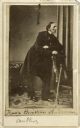
| Date: | 1863 |
|---|---|
| Description: | Full-length carte-de-visite portrait of Hans Christian Andersen (1805-1875), Danish poet and author of fairy tales. Inscription at bottom of card reads, "H... |
| Date: | |
|---|---|
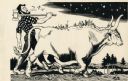
| Description: | Paul Bunyan walking with an axe over his shoulder and whistling. He is accompanied by Babe the Blue Ox who is carrying several people on his back. |
| Date: | |
|---|---|
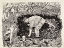
| Description: | Drawing of Paul Bunyan and his blue ox, Babe, hauling off Section 37. Bunyan has an axe over his shoulder and holds a pipe. |
| Date: | |
|---|---|
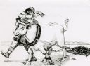
| Description: | Woodcut illustration of Paul Bunyan carrying his blue ox Babe, when Babe was a calf. |
| Date: | |
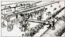
|---|---|
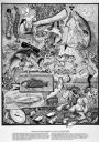
| Description: | Mess hall at Paul Bunyan's lumber camp. Men are seated at long tables as trains dispense soup, coffee, and tea, while salt is hauled in a wagon pulled by e... |
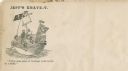
| Date: | 1860 |
|---|---|
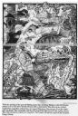
| Description: | Jefferson Davis and six sailors sail in a tea cup. A pirate flag flies overhead. One sailor is in the "crow's nest." Another is using a paddle. Three sailo... |
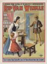
| Date: | 1905 |
|---|---|
| Description: | Color lithograph on paper. Across top in caps "A splendid scenic revival of the greatest of American dramas." Title runs beneath. Scene from play in which ... |

| Date: | 1933 |
|---|---|
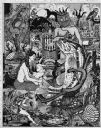
| Description: | Label submitted to the State of Wisconsin for trademark registration. "German Style Beer, Peter Bub Brewery." Pictured on the label are a group of gnomes d... |
| Date: | |
|---|---|
| Description: | Man in a long coat and hat standing with the large Paul Bunyan drum, which is mounted on wheels. |

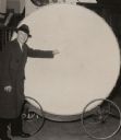
| Date: | 1930 |
|---|---|
| Description: | Original map made with watercolor and inkwash. Includes a legend of buildings, roads, natural features and other details of the lodge. Inset at bottom has ... |
| Date: | 1987 |
|---|---|
| Description: | Imaginative pen-and-ink drawing titled, "Fish Tales (The Truth is Irrelevant, A Lie Well Told Lives Forever)." Sid adds the following words to describe the... |
| Date: | 1985 |
|---|---|
| Description: | Imaginative pen-and-ink drawing that appeared in the Capitol Times May 3, 1985 with Sid's caption: "Charlie Lunker Bass is down at the rustic barber... |
| Date: | 1986 |
|---|---|
| Description: | Imaginative pen-and-ink drawing that appeared in the Capital Times on May 3, 1986 with Sid's caption: "Before fish, all men are created equal. Fish,... |
| Date: | 1974 |
|---|---|
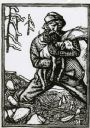
| Description: | Imaginative pen-and-ink drawing of a fisherman in waders, standing in ankle deep water and bending over with one hand in the water. He is looking towards h... |

| Date: | 1627 |
|---|---|
| Description: | Map of North and South America showing settlements, rivers, lakes, mountains, islands and regions of the western hemisphere. It includes an inset map of Gr... |

| Date: | 1690 |
|---|---|
| Description: | A mysterious mixture of mythology, ancient geography, and late 17th century knowledge of the American coastline. This map shows North and South America, bu... |

| Date: | |
|---|---|
| Description: | Sid standing in his kitchen looking at a sculpture of a Viking troll set up on a stool. |

| Date: | 1740 |
|---|---|
| Description: | Map including the regions and cities of the northern half of North America. Native American land, rivers, lakes, mountains are labeled. Mountains, marshes,... |

| Date: | 1759 |
|---|---|
| Description: | Map of north eastern Canada and parts of New England, showing settlements, cities, portages, Native American land, mountains, lakes, and rivers. The unusua... |
If you didn't find the material you searched for, our Library Reference Staff can help.
Call our reference desk at 608-264-6535 or email us at:
