Filter: Categories of Wisconsin Historical Images
Filter: Subject of Flour mills
Filter: Year of 1900-1999
Filter: Year of 1950-1959
Filter: Categories of Wisconsin Historical Images
Filter: Subject of Flour mills
Filter: Year of 1900-1999
Filter: Year of 1950-1959
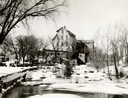
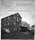
| Date: | 1956 |
|---|---|
| Description: | The stone building formerly housed the flour mill. The mill was established in 1852, but had pretty well gone out of business by 1895, by which time the po... |
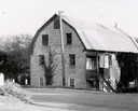
| Date: | 1956 |
|---|---|
| Description: | The stone building formerly housed the flour mill. The mill was established in 1852, but had pretty well gone out of business by 1895, by which time the po... |
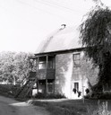
| Date: | 1950 |
|---|---|
| Description: | The Thiensville Mill as seen from the waterfront. |

| Date: | 05 1958 |
|---|---|
| Description: | Photocopy of a map created by the City of Milwaukee Master Plan Program City Planning Division in May of 1958 representing 1870 "THE CENTRAL AREA OF THE CI... |

| Date: | 1950 |
|---|---|
| Description: | Subject: "UD-24 — Cotton Gins." Where Taken: "MidW." Information with photograph reads: "Owned by the Potosi Mill & Elev. Co., Potosi, Mo. All power for mi... |

| Date: | 1950 |
|---|---|
| Description: | Subject: "UD-24 — Cotton Gins." Where Taken: "SW." Information with photograph reads: "Owned by The Luxora Gin Co., Luxora, Ark. Used to provide power for ... |
| Date: | 1950 |
|---|---|
| Description: | Subject: "UD-16 — Industrial Power (Misc.)." Where Taken: "SW." Information with photograph reads: "Owned by Bowman Milling Co., Pocahontas, Mo. Used to po... |
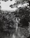
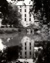
| Date: | 1950 |
|---|---|
| Description: | Mirror Lake, below the dam at Timme Mill. Trees and foliage cover the banks and overhang the water. The one lane high reverse metal truss bridge, commonly ... |
If you didn't find the material you searched for, our Library Reference Staff can help.
Call our reference desk at 608-264-6535 or email us at: