 Filter: Categories of Wisconsin Historical Images
Filter: Subject of Flour mills
Filter: Subject of lakes
Filter: Categories of Wisconsin Historical Images
Filter: Subject of Flour mills
Filter: Subject of lakes

| Date: | 1853 |
|---|---|
| Description: | Farwell's Mill on the Yahara River at Lake Mendota. |

| Date: | 1871 |
|---|---|
| Description: | This map of Barron County, Wisconsin, shows the township and range grid, towns, sections, cities and villages, post offices, dwellings, schools, roads, swa... |

| Date: | 1885 |
|---|---|
| Description: | A detail of a Sanborn map including Catfish Creek and Westport Road by Lake Mendota. |

| Date: | 1851 |
|---|---|
| Description: | This map shows townships, villages, Indian villages, railroads, roads, mills, prairies, swamps, and canals. An inset map shows a plat of the copper distric... |

| Date: | 1890 |
|---|---|
| Description: | Dow Flour Mill letterhead, with an engraving of the mill building, with a locomotive, a ship on the lake, and the dome of the Wisconsin State Capitol. |
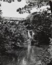
| Date: | 1950 |
|---|---|
| Description: | Mirror Lake, below the dam at Timme Mill. Trees and foliage cover the banks and overhang the water. The one lane high reverse metal truss bridge, commonly ... |
If you didn't find the material you searched for, our Library Reference Staff can help.
Call our reference desk at 608-264-6535 or email us at: