 Filter: Categories of Wisconsin Historical Images
Filter: Subject of Flour mills
Filter: Subject of human settlements
Filter: Categories of Wisconsin Historical Images
Filter: Subject of Flour mills
Filter: Subject of human settlements

| Date: | |
|---|---|
| Description: | Fire at the elevator of the Atlas Flour Mill. Two men are working a water hose tower in the center, and fire fighters are aiming jets of water at the buil... |

| Date: | 06 04 1961 |
|---|---|
| Description: | View of the Honey Creek Rod and Gun Club playground beside Mielke's grist mill. |
| Date: | 04 1926 |
|---|---|
| Description: | Old stone mill, with a smaller wooden addition on the left. Water is passing through the flume. |

| Date: | 06 19 1925 |
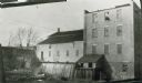
|---|---|
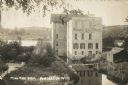
| Description: | Exterior of stone mill. An automobile of the period is parked under the front portico, and there is a wooden wing in the rear. A sign in front advertises "... |
| Date: | |
|---|---|
| Description: | City flour mills, on the Catfish River (Yahara River). The mill burned down in the fall of 1873. |

| Date: | |
|---|---|
| Description: | The Old Stone Mill, a circular stone mill surrounded by a fence with benches nearby, in Turio Park. |
| Date: | 03 15 1911 |
|---|---|
| Description: | Over 15 manure spreaders near railroad cars in small town. They may have been recently transported from Chicago via the Chicago and Northwestern railroad c... |

| Date: | |
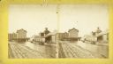
|---|---|
| Description: | A view of Campbell's Mill and the Water Street Bridge in the background on the right. There is a railroad car and several men driving horse-drawn wagons on... |
| Date: | 1920 |
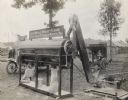
|---|---|
| Description: | A Meadows stone burr grain mill powered by an International Harvester engine grinding wheat into flour at what appears to be an outdoor fair or exhibition.... |
| Date: | |
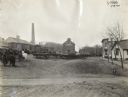
|---|---|
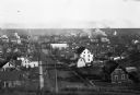
| Description: | View of a town from an overlooking hill. Beyond dwellings, the Russell-Miller Milling Company is visible; it was built in 1906. |
| Date: | 04 29 1900 |
|---|---|
| Description: | View of the Globe Milling Company, built in 1848, and the Lewis Factory on the Rock River. In the distance is a dam, bridge, and barbershop. |

| Date: | 1871 |
|---|---|
| Description: | This map of Barron County, Wisconsin, shows the township and range grid, towns, sections, cities and villages, post offices, dwellings, schools, roads, swa... |

| Date: | 1858 |
|---|---|
| Description: | Map showing roads, mills, and rivers. Date conjectured from presence of Ensign’s Mill and Pitt’s Mill and location of Nekoosa. |

| Date: | 05 1958 |
|---|---|
| Description: | Photocopy of a map created by the City of Milwaukee Master Plan Program City Planning Division in May of 1958 representing 1870 "THE CENTRAL AREA OF THE CI... |

| Date: | |
|---|---|
| Description: | A view of the Wonewoc Mill Company where they manufacture White Swan Flour. Sacks of flour and two men sitting on the loading dock. A woman walking away on... |

| Date: | 1885 |
|---|---|
| Description: | A detail of a Sanborn map including Catfish Creek and Westport Road by Lake Mendota. |

| Date: | 1855 |
|---|---|
| Description: | This map is ink, pen, and watercolor on paper and shows plat of the town, local streets, lots by number, U.S. subdivisions in red lines, Mineral Point Rail... |
| Date: | 1909 |
|---|---|
| Description: | Photographic postcard of an elevated view looking down at the Waterloo Roller Mills and Dam. Caption reads: "Mill and Dam, Waterloo, Wis." |

| Date: | 1851 |
|---|---|
| Description: | This map shows townships, villages, Indian villages, railroads, roads, mills, prairies, swamps, and canals. An inset map shows a plat of the copper distric... |

| Date: | |
|---|---|
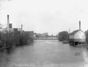
| Description: | View across lawn and the Yahara River towards the Hausmann Brewing Company's Malt House in the center background. On the right is the Yahara River bridge. ... |
If you didn't find the material you searched for, our Library Reference Staff can help.
Call our reference desk at 608-264-6535 or email us at: