Filter: Categories of Wisconsin Historical Images
Filter: Subject of Floods
Filter: Subject of trees
Filter: Categories of Wisconsin Historical Images
Filter: Subject of Floods
Filter: Subject of trees
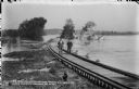
| Date: | 10 12 1911 |
|---|---|
| Description: | Two men are standing on the tracks of the newly constructed railroad extension to the construction site of the Prairie du Sac dam. Behind them, the tracks... |
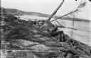
| Date: | 10 18 1911 |
|---|---|
| Description: | Receding flood waters reveal destruction of the railroad extension to the power dam construction site. |
| Date: | 10 18 1911 |
|---|---|
| Description: | Workmen standing on damaged and partly submerged railroad track on the west shore of the Wisconsin River. |
| Date: | 11 05 1911 |
|---|---|
| Description: | A diver and team working to inspect the coffer dam for underwater damage caused by flooding. |
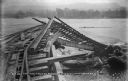
| Date: | 03 19 1913 |
|---|---|
| Description: | A view, looking east, of the wreckage of the high trestle caused by flooding and ice. The concrete plant is visible on the far bank. |
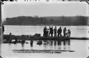
| Date: | 10 12 1911 |
|---|---|
| Description: | High water has scattered timber pilings through the construction camp. The office is on the right; the smokestacks of the temporary power plant are behind ... |
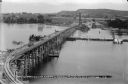
| Date: | 08 01 1912 |
|---|---|
| Description: | Elevated view of the power dam construction site from the west, showing the elevated trestle, coffer dam, and steam pile drivers. The concrete plant is vis... |

| Date: | 02 27 1948 |
|---|---|
| Description: | Flood at the University of Wisconsin-Madison East Hill Trailer Camp, located at 451 North Midvale Boulevard, south of University Avenue. Shown are several ... |

| Date: | 02 27 1947 |
|---|---|
| Description: | Flood at the University of Wisconsin-Madison East Hill Trailer Camp, located at 451 North Midvale Boulevard, south of University Avenue. Looking west, sho... |

| Date: | 03 05 1950 |
|---|---|
| Description: | Flooding along University Avenue at Shorewood Boulevard in front of Frenchy's restaurant, 3302 University Avenue. |

| Date: | 03 05 1950 |
|---|---|
| Description: | Flooding along University Avenue at Shorewood Boulevard. Businesses in the photograph include Frenchy's Restaurant, 3302 University Avenue, and the Walter ... |

| Date: | 04 27 1950 |
|---|---|
| Description: | View of damage to the breakwater behind the home of Dr. J.G. Frisch, 1653 Sherman Avenue, caused by high water and waves driven by strong winds. |
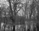
| Date: | 04 18 1965 |
|---|---|
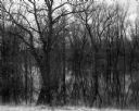
| Description: | View of a wooded area affected by a Wisconsin River flood. |
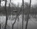
| Date: | 04 18 1965 |
|---|---|
| Description: | View through trees and over water of a small house in a wooded area surrounded by water due to the flooding of the Wisconsin River. |

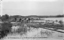
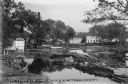
| Date: | 1925 |
|---|---|
| Description: | Elevated view of a small town with a river and bridge in the foreground. High water has washed away the road and river bank at the far end of the bridge. T... |

| Date: | 07 04 1960 |
|---|---|
| Description: | Landscape view of a flooded field at sunrise. |
| Date: | 05 10 1960 |
|---|---|
| Description: | Grove of trees in a flooded area from a late snow melt. |
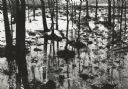
| Date: | 04 17 1965 |
|---|---|
| Description: | Flooded woods near the Wisconsin River. A sign for "The Dutch Kitchen" at Hotel Meyers is nailed to one of the trees. |
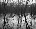
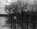
| Date: | 04 18 1965 |
|---|---|
| Description: | View of a grove of trees and their reflections in the flooded Wisconsin River bottomlands. |
If you didn't find the material you searched for, our Library Reference Staff can help.
Call our reference desk at 608-264-6535 or email us at: