 Filter: Categories of Wisconsin Historical Images
Filter: Subject of Fishing
Filter: Subject of water
Filter: Subject of roads
Filter: Categories of Wisconsin Historical Images
Filter: Subject of Fishing
Filter: Subject of water
Filter: Subject of roads

| Date: | 1870 |
|---|---|
| Description: | Bird's-eye view of Whitewater, with insets. |
| Date: | |
|---|---|
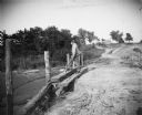
| Description: | A man fishes from an earthen bridge. There is a house or barn in the background. |
| Date: | |
|---|---|
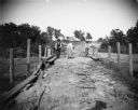
| Description: | Two men fish from an earthen bridge while a woman stands holding a fish. There is a house or barn in the background. |
| Date: | 1870 |
|---|---|
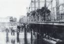
| Description: | A large group of men are snagging sturgeon from a bridge over the Wolf River. A sturgeon is hanging from a line. More men are sitting on a bridge support, ... |
| Date: | |
|---|---|
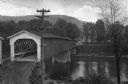
| Description: | Elevated view of a covered bridge spanning the Delaware River. Signs on the bridge read, "$25.00 Fine for Riding or Driving Faster than a Walk on this Brid... |
| Date: | 07 28 1933 |
|---|---|
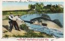
| Description: | Colorized postcard in the Tall-Tale style. Two men standing on the shore are pulling a third man's leg out of a enormous fish's mouth. Two automobiles and ... |

| Date: | 1939 |
|---|---|
| Description: | This map shows the towns to Gingles, Sanborn, and Guney as well as Chequamegon Bay, Kakagon River, White River, Marengo River, Bad River, Potato River, Vau... |

| Date: | 1936 |
|---|---|
| Description: | This pictorial tourist map from the Wisconsin Conservation Commission depicts vacation activities and identifies tourist destinations throughout the state.... |
| Date: | 1920 |
|---|---|
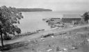
| Description: | View from hill looking down at a wood framed warehouse building on a pier with boats docked alongside. Near the warehouse are fish net drying reels. Wooded... |

| Date: | 1941 |
|---|---|
| Description: | A tourist map of Marinette County, Wisconsin that includes indexes of the lakes and rivers in the county which also identify the fish present, a list of ra... |

| Date: | 1935 |
|---|---|
| Description: | This pictorial map of northern Bayfield County, Wisconsin, shows the Chequamegon National Forest, the Red Cliff Indian Reservation, highways and roads, and... |

| Date: | 1895 |
|---|---|
| Description: | This late 19th century map of northern Wisconsin and a portion of Michigan's Upper Peninsula shows the township and range grid, the (Lac du) Flambeau India... |

| Date: | 1986 |
|---|---|
| Description: | This late 1980s map of Price County, Wisconsin, shows facilities and lands open for public recreation, hunter walking trails and ski trails, campgrounds, b... |

| Date: | 1976 |
|---|---|
| Description: | Panel title. Shows railroads, roads, highways, boundaries, dams, public hunting and fishing grounds, cemeteries, forest ranger stations, plant life, and s... |
| Date: | 1902 |
|---|---|
| Description: | Scene along “Willow Drive,” later known as "University Drive," on the shore of Lake Mendota, showing the neo-Gothic carved bridge. View from shoreline of t... |

| Date: | |
|---|---|
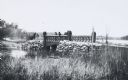
| Description: | View from bridge towards three men standing on the bridge and fishing. The road in the background rises up a small hill, and a building is in the distance. |

| Date: | 1908 |
|---|---|
| Description: | This map shows counties, roads, Lake Superior, Lake Michigan, and portions of surrounding states. Also included is a list of railroads showing miles and g... |

| Date: | 1910 |
|---|---|
| Description: | This map shows counties, roads, Lake Superior, Lake Michigan, and portions of surrounding states. Also included is a list of railroads showing miles and gr... |

| Date: | 1980 |
|---|---|
| Description: | This map shows schools, hotels, stations, roads, railroads, reefs, and public buildings. The upper right corner includes "A Summer and Winter Guide for Spo... |

| Date: | 1936 |
|---|---|
| Description: | This map shows campsites, trails, auto roads, surrounding townships, and points of interest, by including pictorial illustrations. Includes an inserted map... |
If you didn't find the material you searched for, our Library Reference Staff can help.
Call our reference desk at 608-264-6535 or email us at: