 Filter: Categories of Wisconsin Historical Images
Filter: Subject of Fishing
Filter: Subject of water
Filter: Subject of deer
Filter: Categories of Wisconsin Historical Images
Filter: Subject of Fishing
Filter: Subject of water
Filter: Subject of deer

| Date: | |
|---|---|
| Description: | Wisconsin promotional decal with a map of the state, with many cities marked and drawings of some Wisconsin icons: cheese, cows, deer, beer, Wisconsin Dell... |

| Date: | 1759 |
|---|---|
| Description: | Map of north eastern Canada and parts of New England, showing settlements, cities, portages, Native American land, mountains, lakes, and rivers. The unusua... |
| Date: | |
|---|---|
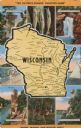
| Description: | Printed color postcard. In the center is a map of Wisconsin with towns, rivers and other attractions over a yellow background. Around the outside is a doub... |

| Date: | |
|---|---|
| Description: | Map showing the location of the Little Bohemia lodge and restaurant, with major routes from Chicago and eastern and central Wisconsin. |
If you didn't find the material you searched for, our Library Reference Staff can help.
Call our reference desk at 608-264-6535 or email us at: