 Filter: Categories of Wisconsin Historical Images
Filter: Subject of Fishing
Filter: Type of Map or Atlas
Filter: Year of 1900-1999
Filter: Year of 1950-1959
Filter: Categories of Wisconsin Historical Images
Filter: Subject of Fishing
Filter: Type of Map or Atlas
Filter: Year of 1900-1999
Filter: Year of 1950-1959
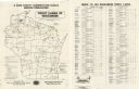
| Date: | 1956 |
|---|---|
| Description: | A map that identifies the trout lakes in Wisconsin and their proximity to cities. Text on the page of the map highlights the conservation actions taken by ... |
| Date: | 1950 |
|---|---|
| Description: | This map covers the fifteen counties lying in the northwestern part of the state of Wisconsin. Shows roads, railroads, state parks, cities, county boundari... |

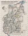
| Date: | 1958 |
|---|---|
| Description: | This map shows state public hunting and/or fishing grounds, national forests, state forests, county forests.The lower margin includes an index to these loc... |
If you didn't find the material you searched for, our Library Reference Staff can help.
Call our reference desk at 608-264-6535 or email us at: