 Filter: Categories of Wisconsin Historical Images
Filter: Subject of Fishing
Filter: Type of Map or Atlas
Filter: Subject of economics
Filter: Categories of Wisconsin Historical Images
Filter: Subject of Fishing
Filter: Type of Map or Atlas
Filter: Subject of economics

| Date: | 1940 |
|---|---|
| Description: | This pictorial map shows points of interest, recreation activities, and highways in the vicinity of the restaurant and covers the Wisconsin River Valley be... |

| Date: | 1975 |
|---|---|
| Description: | This map shows nature trails, public attractions, public hunting and fishing grounds, dams, waysides, lakes, highways, and roads. The upper right corner in... |

| Date: | 1991 |
|---|---|
| Description: | This map shows public access, fish crib locations, resorts, and other local businesses as well as advertisements for local attractions and a resort index. ... |

| Date: | 1922 |
|---|---|
| Description: | This map shows in red the NorthWestern Railway Line routes running from Chicago, Illinois to northern Wisconsin. The map includes cities and towns, lakes, ... |
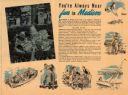
| Date: | |
|---|---|
| Description: | This map of Madison is also a brochure of activities for vacationers in the area. Includes indexes and some points of interest shown pictorially. |
If you didn't find the material you searched for, our Library Reference Staff can help.
Call our reference desk at 608-264-6535 or email us at: