 Filter: Categories of Wisconsin Historical Images
Filter: Subject of Fishes
Filter: Subject of recreation
Filter: Type of Map or Atlas
Filter: Categories of Wisconsin Historical Images
Filter: Subject of Fishes
Filter: Subject of recreation
Filter: Type of Map or Atlas
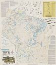
| Date: | 1987 |
|---|---|
| Description: | This map shows creeks, lakes, ponds, and rivers. Also included are illustrations and a table of trout food, tips on trout fishing and notes on top trout st... |

| Date: | 1958 |
|---|---|
| Description: | This map shows state public hunting and/or fishing grounds, national forests, state forests, county forests.The lower margin includes an index to these loc... |

| Date: | 1715 |
|---|---|
| Description: | One of Herman Moll's most famous maps, often referred to as The Codfish Map, it shows rivers and portages, cities, Indian villages, wind directions, routes... |

| Date: | |
|---|---|
| Description: | Map showing the location of the Little Bohemia lodge and restaurant, with major routes from Chicago and eastern and central Wisconsin. |
If you didn't find the material you searched for, our Library Reference Staff can help.
Call our reference desk at 608-264-6535 or email us at: