 Filter: Categories of Wisconsin Historical Images
Filter: Subject of Fires
Filter: Subject of human settlements
Filter: Subject of disasters
Filter: Type of Map or Atlas
Filter: Categories of Wisconsin Historical Images
Filter: Subject of Fires
Filter: Subject of human settlements
Filter: Subject of disasters
Filter: Type of Map or Atlas

| Date: | |
|---|---|
| Description: | Map of the district of the Peshtigo fire, approximately 1,280,000 acres, in Wisconsin and Upper Michigan. |

| Date: | 1875 |
|---|---|
| Description: | Bird's-eye map after a fire destroyed a large area of the town. In memory of the Great Conflagration on April 28th, 1875. Taken from the North-Side. |
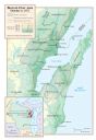
| Date: | 1999 |
|---|---|
| Description: | Map depicting the burned over area created by the fire on October 8, 1871. Map includes inset of Wisconsin and surrounding states with detail of area impac... |
If you didn't find the material you searched for, our Library Reference Staff can help.
Call our reference desk at 608-264-6535 or email us at: