Filter: Categories of Wisconsin Historical Images
Filter: Subject of Fire extinction
Filter: Year of 1900-1999
Filter: Year of 1900-1909
Filter: Categories of Wisconsin Historical Images
Filter: Subject of Fire extinction
Filter: Year of 1900-1999
Filter: Year of 1900-1909
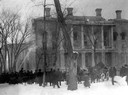
| Date: | 02 27 1904 |
|---|---|
| Description: | Wisconsin State Capitol fire, showing a crowd watching near the South Wing. Some of the contents of the building are already in wagons ready to be hauled a... |
| Date: | 02 27 1904 |
|---|---|
| Description: | Fire at the third Wisconsin State Capitol, showing the South Wing, and spectators gathered on the path. Some of the salvaged contents of the building are s... |
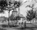
| Date: | 1900 |
|---|---|
| Description: | The Madison City Water Works pumping station at the intersection of Gorham and Livingston which provided pressure to the city's mains. A group of people st... |
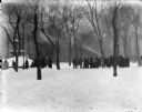
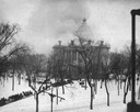
| Date: | 02 1904 |
|---|---|
| Description: | A crowd watches as a stream of water is trained on the south wing of the burning third Wisconsin State Capitol. The Centennial Fountain, with a winter cove... |

| Date: | 1903 |
|---|---|
| Description: | Map shows location of government buildings, schools, churches, parks, and other points of interest. The upper left hand margin features a "Reference" secti... |

| Date: | 1900 |
|---|---|
| Description: | This map of Three Lakes shows forest fire lookout towers, picnic grounds, an airport, roads, and railroad. The map features text boxes on the Village of Th... |

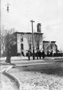
| Date: | 09 26 1908 |
|---|---|
| Description: | Gutted remains of St. Joseph's Church in the aftermath of the fire of September 26, 1908. |

| Date: | 1907 |
|---|---|
| Description: | A group of fire fighters are posing on a horse-drawn hook and ladder firetruck parked at the entrance of the firehouse. Caption reads: "Hook and Ladder Cen... |

| Date: | 04 1901 |
|---|---|
| Description: | A Sanborn map of Watertown, including an index and a key. |

| Date: | 1908 |
|---|---|
| Description: | A Sanborn fire map of Brodhead. Includes an inset at top right showing distances from P.O. |
If you didn't find the material you searched for, our Library Reference Staff can help.
Call our reference desk at 608-264-6535 or email us at: