Filter: Categories of Wisconsin Historical Images
Filter: Subject of Fields (Agriculture)
Filter: County of Dodge
Filter: Categories of Wisconsin Historical Images
Filter: Subject of Fields (Agriculture)
Filter: County of Dodge

| Date: | 05 30 1949 |
|---|---|
| Description: | "This rail fence was on the Myron Weninger farm on County D. In the distance are buildings on the Paul Beckman farm." |

| Date: | 1962 |
|---|---|
| Description: | "This is Doyle Road, looking north, near where it intersects with Allen Road." Taken through the windsheild of the photograhper's car. |
| Date: | 07 04 1949 |
|---|---|
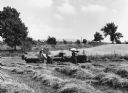
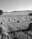
| Description: | "Hay was being made on the Edwin Schnitzler farm on Doyle Road." |
| Date: | 09 25 1947 |
|---|---|
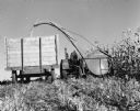
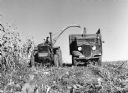
| Description: | "Nick Koll and his son pick corn near Bancroft Road." |
| Date: | 07 19 1949 |
|---|---|
| Description: | "Fields of grain were photographed from Highway 41 (now Highway 175) south of Theresa." |

| Date: | 07 19 1949 |
|---|---|
| Description: | "Cows graze along the Rock River southeast of Theresa." |

| Date: | |
|---|---|
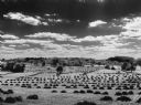
| Description: | View of rows of field crops surrounded by other farmland. |

| Date: | 03 12 1950 |
|---|---|
| Description: | "This little brook is located near Raccoon Road." |
| Date: | 1955 |
|---|---|
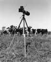
| Description: | "Cows were nosy when a camera was set up in a field near Theresa." |

| Date: | 1955 |
|---|---|
| Description: | "Cows were nosy when a camera was set up in a field near Theresa." |

| Date: | 04 12 1949 |
|---|---|
| Description: | "These houses on Church Street were photographed from the intersection of Henni & Wisconsin Streets. Note the outhouses!" |
| Date: | |
|---|---|
| Description: | "This field is located south of Theresa." |

| Date: | |
|---|---|
| Description: | "Cows graze along the Rock River. In the distance is North Pole Road and beyond that tracks of the Soo Line Railroad." |

| Date: | 07 05 1959 |
|---|---|
| Description: | "Shirley Widmer reminisces on Spring Valley Road." |

| Date: | 1968 |
|---|---|
| Description: | "Brenda Widmer walks her dog Bonnie next to the disposal system. In distance is Sunny Brae farm, site of present-day Schnitzler River View Hills mobile hom... |
| Date: | 1968 |
|---|---|
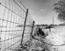
| Description: | "Brenda & Kay Widmer examine an ice covered fence on the Jim Dobbe Farm (Sunny Brae Farm)." |
If you didn't find the material you searched for, our Library Reference Staff can help.
Call our reference desk at 608-264-6535 or email us at: