Filter: Categories of Wisconsin Historical Images
Filter: Subject of Fields (Agriculture)
Filter: County of Dane
Filter: Subject of botany
Filter: Categories of Wisconsin Historical Images
Filter: Subject of Fields (Agriculture)
Filter: County of Dane
Filter: Subject of botany

| Date: | 1873 |
|---|---|
| Description: | Main Street, with its dirt, ruts, cows (and presumably manure), but wide enough for easy hitching of wagons and teams. |

| Date: | 1862 |
|---|---|
| Description: | Camp Randall looking southwest. In April 1861, Governor Alexander Randall asked that the State Agricultural Society fairgrounds be converted into a militar... |
| Date: | 1916 |
|---|---|
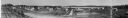
| Description: | Panoramic view of the Wingra area from the railroad tracks north of Gregory Street. Looking towards Lake Wingra, across Monroe Street. |
| Date: | 1879 |
|---|---|
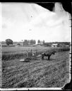
| Description: | Three men taking a break during harvesting. Their horse-drawn reaper raked the grain into rows as it cut. In the background are various farmstead buildings... |

| Date: | 1956 |
|---|---|
| Description: | Aerial view of the South Park Street interchange. |

| Date: | 1908 |
|---|---|
| Description: | Aerial view of Camp Randall Field on the University of Wisconsin-Madison campus. University Heights is in the background. |

| Date: | 12 01 1962 |
|---|---|
| Description: | A farm road between fields in late sunlight, looking towards Mounds Creek in the vicinity of CTH F. |

| Date: | 1950 |
|---|---|
| Description: | Aerial view of the Frank Lloyd-Wright-dsigned Unitarian Church under construction and the Veteran's Administration Hospital, also under construction, to th... |
| Date: | |
|---|---|
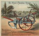
| Description: | Inside spread of 4-page advertising brochure for Fuller & Johnson Mfg. Co. Limited with a chromolithograph of a Bonanza Forge Drop planter, "The only perfe... |
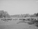
| Date: | 10 10 1945 |
|---|---|
| Description: | Herd of beef cattle in a field near Marshall, Wisconsin. |
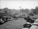
| Date: | 09 10 1945 |
|---|---|
| Description: | Elevated view of a Findorff truck and earthmover and Madison Sand and Gravel truck standing ready to excavate for an addition to the Red Dot Foods, Incorpo... |
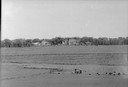
| Date: | 05 24 1945 |
|---|---|
| Description: | Long distance view of Blaney Seed Farm and buildings, at Syene & Lacy Roads. |
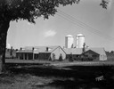
| Date: | 06 30 1944 |
|---|---|
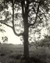
| Description: | Rennebohm dairy farm buildings, showing house in foreground and barn and silos in background, framed by large tree, located 5 miles from the capitol on Hig... |

| Date: | 08 22 1942 |
|---|---|
| Description: | Remodeled trailer house near the intersection of Highways 18 & 51 (Monona Drive and East Broadway). |
| Date: | 09 04 1938 |
|---|---|
| Description: | Accident scene on Highway 12-18 one-half mile east of the Dane County fairgrounds. Close-up of front of automobile, with bicycle under the car. Katherine B... |
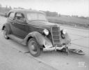
| Date: | 07 17 1934 |
|---|---|
| Description: | Two railroad freight cars with Fauerbach Beer signs covering their sides are parked outdoors on railroad tracks in a railroad yard. |
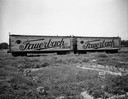
| Date: | 05 26 1932 |
|---|---|
| Description: | At Royal Airport, a line of airplanes are parked in a row in a field. In the background is a hangar with automobiles parked nearby. |
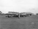
| Date: | 03 04 1932 |
|---|---|
| Description: | Piper Brothers farm scene, 4718 Odana Road near Midvale. |
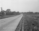
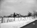
| Date: | 10 20 1931 |
|---|---|
| Description: | Accident scene on Highway 51, rural area. Caption at bottom reads: "High #51 — Looking West — Northwest — October 20, 1931 2:00 P.M." |
If you didn't find the material you searched for, our Library Reference Staff can help.
Call our reference desk at 608-264-6535 or email us at: