 Filter: Categories of Wisconsin Historical Images
Filter: Subject of Field crops
Filter: Subject of lakes
Filter: Categories of Wisconsin Historical Images
Filter: Subject of Field crops
Filter: Subject of lakes
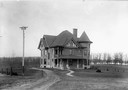
| Date: | 1900 |
|---|---|
| Description: | View of the University of Wisconsin residence of William Arnon Henry, Dean of Agriculture, 10 Babcock Drive with Lake Mendota in the background. |
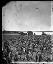
| Date: | 1875 |
|---|---|
| Description: | View from Southeast shore of Lake Monona across a cornfield, perhaps on the farm of Thomas Williamson. |
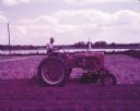
| Date: | 1952 |
|---|---|
| Description: | View across field towards J.A. Coon with a McCormick Farmall Super C tractor and a C-254 cultivator. There is a pond or lake in the background. The origina... |
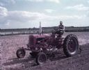
| Date: | 1952 |
|---|---|
| Description: | View towards a man using a McCormick Farmall Super C tractor with a C-254 cultivator to work in a field. There is a pond or lake in the background. The ori... |

| Date: | 1935 |
|---|---|
| Description: | This map shows in different colors virgin timberland, second growth timber, pasture belt, crop-pasture belt, intensive crop-pasture belt, intensive pasture... |

| Date: | 1914 |
|---|---|
| Description: | A hand-colored map of Wisconsin showing the locations of cities and towns, counties, railway lines, the steamship lines in Lake Superior and lake Michigan.... |
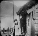
| Date: | |
|---|---|
| Description: | A farming couple pose together on the steps of a building with a sod roof in Nordfjord country. In the background is a lake and a mountain on the far shore... |

| Date: | 1900 |
|---|---|
| Description: | Elevated view of a man using a binder in a field. Sheaves of wheat are distributed in the field, and two other men are standing near the binder. There is a... |

| Date: | 1900 |
|---|---|
| Description: | View across field towards man using horse-drawn binder in a field. Two other people are standing in the field, and two horses are standing on the far left.... |

| Date: | 1923 |
|---|---|
| Description: | This map includes an explanation that reads: "This chart shows the movement of barley on the Great Lakes, St. Lawrence River, and New York State Barge Cana... |

| Date: | 1923 |
|---|---|
| Description: | This map includes an explanation that reads: "This chart shows the movement of corn on the Great Lakes, St. Lawrence River, and New York State Barge Canal ... |

| Date: | 1923 |
|---|---|
| Description: | This map includes an explanation that reads: "This chart shows the easterly movement of flaxseed on the Great Lakes, St. Lawrence River, and New York State... |

| Date: | 1923 |
|---|---|
| Description: | This map includes an explanation that reads: "This chart shows the movement of grain on the Great Lakes, St. Lawrence River, and New York State Barge Canal... |

| Date: | 1923 |
|---|---|
| Description: | This map includes an explanation that reads: "This chart shows the movement of oats on the Great Lakes, St. Lawrence River, and New York State Barge Canal ... |

| Date: | 1923 |
|---|---|
| Description: | This map includes an explanation that reads: "This chart shows the movement of rye on the Great Lakes, St. Lawrence River, and New York State Barge Canal d... |

| Date: | 1900 |
|---|---|
| Description: | View across field towards a man using a horse-drawn reaper in a field. Behind him on the left is a man using a rake to bind the grain. In the background is... |

| Date: | 1900 |
|---|---|
| Description: | Right side view of a man using a horse-drawn reaper in a field. Behind him on the left is a man. In the background is a lake. |

| Date: | 1946 |
|---|---|
| Description: | This bird's-eye-view map shows scenes of land use and farming superimposed on a map of the United States. Agricultural scenes of farming, livestock, and cr... |

| Date: | 1685 |
|---|---|
| Description: | A detailed map of the western hemisphere showing cities, settlements, Native American land, rivers, lakes, mountains, the Great Lakes, and California as an... |
If you didn't find the material you searched for, our Library Reference Staff can help.
Call our reference desk at 608-264-6535 or email us at: