 Filter: Categories of Wisconsin Historical Images
Filter: Subject of Ferries
Filter: Year of 1900-1999
Filter: Categories of Wisconsin Historical Images
Filter: Subject of Ferries
Filter: Year of 1900-1999

| Date: | 1915 |
|---|---|
| Description: | View from shoreline of ferry carrying three automobiles on the Mississippi River. An excursion boat is in the water nearby, and buildings are on the far sh... |

| Date: | 1915 |
|---|---|
| Description: | Ferry tied up at the Cassville dock. A number of men are standing along the shoreline. |
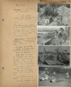
| Date: | 07 22 1941 |
|---|---|
| Description: | Scrapbook page of trip highlights from a bike hosteling trip to Pine Bluff (Dane County), Sauk City (Sauk County), and Okee (Columbia County), sponsored by... |

| Date: | 1940 |
|---|---|
| Description: | This tourist map of Door County, Wisconsin, lists the points of interest and tourist hotels, cabins and cottages in the area. Ferry schedules to Washington... |

| Date: | 1911 |
|---|---|
| Description: | This map of Duluth and Superior shows street car routes, railroads, ferries, some points of interest, and lighthouses. The bottom left of the map reads: "C... |

| Date: | 1966 |
|---|---|
| Description: | A colored map depiction of Door County, Wisconsin, with pictorial highlights, titled: "Door County — Wisconsin's Air Conditioned Peninsula Playground." |
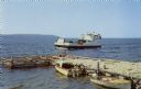
| Date: | 1961 |
|---|---|
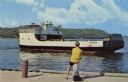
| Description: | Color postcard view of the "Voyageur," a car and passenger ferry operating between mainland Door County and Washington Island. Two motorboats are moored on... |
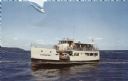
| Date: | 1950 |
|---|---|
| Description: | Color photographic postcard of the "C.G. Richter," a ferry operating between mainland Door County and Washington Island in Wisconsin. |
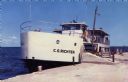
| Date: | 1950 |
|---|---|
| Description: | Color photographic postcard view of the "C.G. Richter" at the dock, a ferry operating between mainland Door County and Washington Island. |
| Date: | 1950 |
|---|---|
| Description: | View from dock towards the Washington Island Ferry, "Eyrarbakki." There is a person sitting on a post on the dock. |
| Date: | 09 15 1960 |
|---|---|
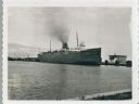
| Description: | View across water towards a carferry named "City of Flint," moored at a dock. There are buildings on the dock on the right. |

| Date: | 12 17 1957 |
|---|---|
| Description: | Carferry slip with pilings in the foreground, and a shoreline in the background. The pier is made of timbers. In the background on the left is a factory wi... |

| Date: | 1923 |
|---|---|
| Description: | This map shows portions of Minnesota, Iowa, Wisconsin, Illinois, Indiana, Ohio, Michigan, New York, Vermont, Massachusetts, Connecticut, Ontario, and Quebe... |

| Date: | 1900 |
|---|---|
| Description: | This map shows the boundary lines between ceded and unceded land in compliance with the Treaty of Prairie du Chen of 1829. It also shows roads, rivers, por... |

| Date: | 1933 |
|---|---|
| Description: | This map shows the major highways and freeways of Wisconsin as well as road surfaces, state parks, points of interest, ferry routes, bridges, and towns whe... |

| Date: | 1936 |
|---|---|
| Description: | This map shows road surfaces, construction, flying fields, seaplane landings, populations of cities and towns, and ferry routes of Wisconsin and some of th... |

| Date: | 1982 |
|---|---|
| Description: | This map shows the location of major settlement regions for various ethnic groups. Includes a legend in lower left hand corner. Sparse settlement is repres... |
| Date: | 06 05 1955 |
|---|---|
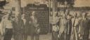
| Description: | Officials gathered to dedicate the Knaggs Ferry historical marker in Oshkosh. The officials included, from left to right, Edward Hamilton, vice-president o... |
| Date: | 06 05 1955 |
|---|---|
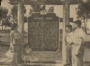
| Description: | Fourth, fifth, and sixth generations of the Knaggs family gathered by the Knaggs Ferry historical marker to honor their family member. Mrs. Walter Dugolens... |

| Date: | 1930 |
|---|---|
| Description: | This map shows the entire state plus portions of Illinois, Iowa, Minnesota, and Michigan outlined in blue. The map shows roads, state parks (black triangle... |
If you didn't find the material you searched for, our Library Reference Staff can help.
Call our reference desk at 608-264-6535 or email us at: