 Filter: Categories of Wisconsin Historical Images
Filter: Subject of Ferries
Filter: Year of 1800-1899
Filter: Subject of cities and towns
Filter: Categories of Wisconsin Historical Images
Filter: Subject of Ferries
Filter: Year of 1800-1899
Filter: Subject of cities and towns
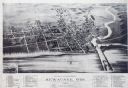
| Date: | 1893 |
|---|---|
| Description: | Bird's-eye map of Kewaunee, with inset of The Kewaunee and Frankfort Car Ferry Line. |
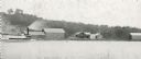
| Date: | 05 02 1849 |
|---|---|
| Description: | The ferry landing in Weston, Missouri; Sketched by Wilkins on his 151-day journey from Missouri to California on the Overland Trail (also known as the Oreg... |
| Date: | 05 17 1849 |
|---|---|
| Description: | The ferry at Nodaway, Missouri; Sketched by Wilkins on his 151-day journey from Missouri to California on the Overland Trail (also known as the Oregon Trai... |
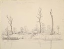
| Date: | 1895 |
|---|---|
| Description: | Rumsey's Landing on the Chippewa River about two miles below Caryville. |
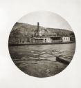
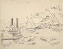
| Date: | 05 10 1894 |
|---|---|
| Description: | View of a ferry with the name Liberty from the Ohio River. A row of buildings in the background along a street near the river include a hotel. |

| Date: | 1862 |
|---|---|
| Description: | This detailed map shows batteries and rifle pits, railroads, common and military roads, turnpikes, city streets and names, bridges, ferries, rural houses a... |

| Date: | 05 01 1899 |
|---|---|
| Description: | Map showing the Schuylkill River with roads, ferries, and points of interest from Valley Forge to Philadelphia, Pennsylvania as it appeared during the Revo... |
If you didn't find the material you searched for, our Library Reference Staff can help.
Call our reference desk at 608-264-6535 or email us at: