Filter: Categories of Wisconsin Historical Images
Filter: Subject of Ferries
Filter: Subject of rivers
Filter: Year of 1900-1999
Filter: Categories of Wisconsin Historical Images
Filter: Subject of Ferries
Filter: Subject of rivers
Filter: Year of 1900-1999
| Date: | 1940 |
|---|---|
| Description: | Colsac Ferry across the Wisconsin River at Merrimac. There is a bridge across the river in the background on the left. |
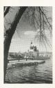
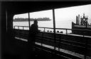
| Date: | 1969 |
|---|---|
| Description: | The Island's Edge, Williamsburg Bridge, East River. |
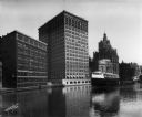
| Date: | 07 13 1915 |
|---|---|
| Description: | Looking south from Wells Street. A boat travels along the Milwaukee River in the foreground. Landmarks left to right: Manufacturers Home Building, First Na... |
| Date: | 1900 |
|---|---|
| Description: | Car boarding the ferry on left side. The far shoreline can be seen in the background. |

| Date: | 10 1972 |
|---|---|
| Description: | Gaylord Nelson, Patrick Lucey, and Walter Mondale look over the St. Croix River. In the background a bridge is under construction. |
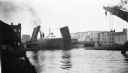
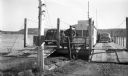
| Date: | 06 1939 |
|---|---|
| Description: | Bridge on the Manitowoc River raised to allow the Pere Marquette car ferry through. River dredging equipment can be seen in the foreground. |
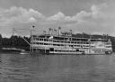
| Date: | 1930 |
|---|---|
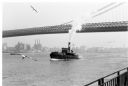
| Description: | View of the steamship "Island Queen," near Coney Island, which is on the Ohio River near Cincinatti. "Island Queen Coney Island" is painted on the rear of ... |

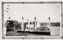
| Date: | 1915 |
|---|---|
| Description: | View of the Richmond and Dresden ferry in the Kennebec River, about to land. A man and a horse with cart are on the ferry. Several canoes and a sailboat is... |

| Date: | 1910 |
|---|---|
| Description: | View of a cable ferry in the Cuyahoga River. A man and several chairs are on the ferry. A rocky pass is further down the river. |
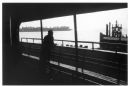
| Date: | 1968 |
|---|---|
| Description: | Two passengers stand over a bench and look out of the ferry towards the water. The developed shoreline and a pier with a seagull perched on top can be see... |

| Date: | 1908 |
|---|---|
| Description: | Men, women and children transporting horses and a loaded wagon across a river on a ferry. |

| Date: | 1944 |
|---|---|
| Description: | This nine-part map from the U.S. Bureau of Public Roads identifies federal and state highways in Wisconsin by pavement type. County, forest, park, and publ... |

| Date: | 1950 |
|---|---|
| Description: | This road map shows federal, state and county roads in Wisconsin, northern Illinois, northeastern Iowa, eastern Minnesota, and the western portion of Michi... |
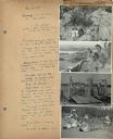
| Date: | 07 22 1941 |
|---|---|
| Description: | Scrapbook page of trip highlights from a bike hosteling trip to Pine Bluff (Dane County), Sauk City (Sauk County), and Okee (Columbia County), sponsored by... |

| Date: | 1900 |
|---|---|
| Description: | This map shows the boundary lines between ceded and unceded land in compliance with the Treaty of Prairie du Chen of 1829. It also shows roads, rivers, por... |

| Date: | 1936 |
|---|---|
| Description: | This map shows road surfaces, construction, flying fields, seaplane landings, populations of cities and towns, and ferry routes of Wisconsin and some of th... |

| Date: | 1930 |
|---|---|
| Description: | This map shows the entire state plus portions of Illinois, Iowa, Minnesota, and Michigan outlined in blue. The map shows roads, state parks (black triangle... |

| Date: | 1928 |
|---|---|
| Description: | This map shows the entire state of Wisconsin as well as portions of Michigan, Minnesota, Iowa and Illinois. Lake Michigan, Lake Superior, Lake Winnebago a... |
If you didn't find the material you searched for, our Library Reference Staff can help.
Call our reference desk at 608-264-6535 or email us at: