 Filter: Categories of Wisconsin Historical Images
Filter: Subject of Farms
Filter: Year of 1800-1899
Filter: Year of 1840-1849
Filter: Categories of Wisconsin Historical Images
Filter: Subject of Farms
Filter: Year of 1800-1899
Filter: Year of 1840-1849
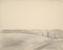
| Date: | 05 1849 |
|---|---|
| Description: | A farm in Missouri with one wagon visible. Sketched by Wilkins on his 151-day journey from Missouri to California on the Overland Trail (also known as the ... |
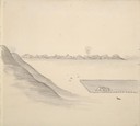
| Date: | 05 1849 |
|---|---|
| Description: | The bottom lands and a farm in Missouri; Sketched by Wilkins on his 151-day journey from Missouri to California on the Overland Trail (also known as the Or... |

| Date: | 1847 |
|---|---|
| Description: | Shows parts of northeastern Iowa County, northwestern Dane County, and the extreme southern part of Sauk County "shewing the position of the British Temper... |
If you didn't find the material you searched for, our Library Reference Staff can help.
Call our reference desk at 608-264-6535 or email us at: