 Filter: Categories of Wisconsin Historical Images
Filter: Subject of Farms
Filter: Subject of land use
Filter: Subject of streets
Filter: Categories of Wisconsin Historical Images
Filter: Subject of Farms
Filter: Subject of land use
Filter: Subject of streets
| Date: | |
|---|---|
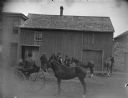
| Description: | Men displaying horses. The man in the center is probably John Meek. Buildings are along the opposite side of the street. |

| Date: | |
|---|---|
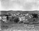
| Description: | Elevated view of Mount Horeb from the water tower. Homes and commercial structures dominate the left side, while farmland and newly-developed tracts are to... |
| Date: | 1913 |
|---|---|
| Description: | Elevated view from hill of the town and hills in the distance. |
| Date: | 02 02 1978 |
|---|---|
| Description: | "The camera looks to the new subdivision and beyond." |
| Date: | |
|---|---|
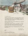
| Description: | Letterhead of Patek Brothers, Inc., of Milwaukee, Wisconsin, a paint company, with a halftone image of a hand dipping a brush into a can of Patek paint, el... |
| Date: | 1910 |
|---|---|
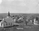
| Description: | Elevated view from hill of Mount Sterlings's churches, homes, and businesses. |

| Date: | 1925 |
|---|---|
| Description: | Elevated view of Mount Vernon from the a grassy hill. |

| Date: | 1929 |
|---|---|
| Description: | Elevated view of Viola and neighboring farms in a valley surrounded by rolling hills. |

| Date: | 1908 |
|---|---|
| Description: | Elevated photographic postcard view of town showing homes and businesses. A windmill is in the foreground. The school is on the far edge of town on the lef... |

| Date: | 1934 |
|---|---|
| Description: | This map shows industrial points of interest in Superior. The top of the map reads: "Superior, Douglas County, Wisconsin, as this Industrial Tour map indic... |

| Date: | 1956 |
|---|---|
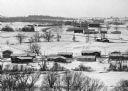
| Description: | Aerial view of residential homes, farmland and streets. |

| Date: | 1871 |
|---|---|
| Description: | This map shows buildings, roads, the railroad, an orchard, and swamp land. Relief shown by hachures. The map includes an index of buildings in the upper ri... |

| Date: | 1830 |
|---|---|
| Description: | This map is ink, color, and pencil on paper and shows streets, farm lots, and a church. Handwritten notes are at the bottom of the map and are very light. |

| Date: | 1838 |
|---|---|
| Description: | This map is a development plat that shows street names, numbered blocks and lots, and small farm lot owners. Included on the right of the map is a large am... |

| Date: | 1857 |
|---|---|
| Description: | This map shows lots and streets and includes pencil manuscript notations on the front and certification statements on the reverse. The top left margin read... |

| Date: | 1855 |
|---|---|
| Description: | This map shows streets and lots. The right side of the map includes notes on widths of streets and certifications. The top right reads: "Parish's Addition ... |

| Date: | 1865 |
|---|---|
| Description: | This is a collection of two plat maps. The first map shows lots, streets, and farm lot 25. Written in ink, the top of the map reads: Plat of Prairie du Chi... |

| Date: | 1913 |
|---|---|
| Description: | This photocopy map shows plots with owners' names, land use both commercial and agricultural, and lot outlines on University land. Lake Mendota is labeled ... |

| Date: | 1776 |
|---|---|
| Description: | Fairly detailed map of New York City and parts of Long Island. It shows streets, roads, wharves, ferries, ship yards, Fort George and the battery, public b... |
If you didn't find the material you searched for, our Library Reference Staff can help.
Call our reference desk at 608-264-6535 or email us at: