 Filter: Categories of Wisconsin Historical Images
Filter: Subject of Farms
Filter: County of Grant
Filter: Creator Name of Unknown
Filter: Categories of Wisconsin Historical Images
Filter: Subject of Farms
Filter: County of Grant
Filter: Creator Name of Unknown

| Date: | |
|---|---|
| Description: | View from road of a stone one-room school house and shed. In the background is a field and farm buildings. |

| Date: | 1928 |
|---|---|
| Description: | Shows different types of roads, railroads, schools, churches, farmsteads, cheese factories, mine shafts, old surface workings, streams, old sulphur pits, a... |

| Date: | 1908 |
|---|---|
| Description: | Elevated photographic postcard view of town showing homes and businesses. A windmill is in the foreground. The school is on the far edge of town on the lef... |
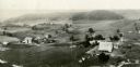
| Date: | 1930 |
|---|---|
| Description: | Aerial view of two farms, with fields and barns in a valley. This image appeared in Joseph Schafer's 1932 book The Wisconsin Lead Region, on a photo... |
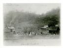
| Date: | |
|---|---|
| Description: | View towards a farm at the base of a hillside, with smoke coming out of a chimney on a farmhouse, and two outbuildings. A group of eight people are posing ... |

| Date: | 1953 |
|---|---|
| Description: | View from front towards two horses pulling a plow in a field being driven by a boy. On the right an older man is walking beside the team, and in the backgr... |
If you didn't find the material you searched for, our Library Reference Staff can help.
Call our reference desk at 608-264-6535 or email us at: