 Filter: Categories of Wisconsin Historical Images
Filter: Subject of Farms
Filter: Community of Madison
Filter: Subject of outdoor photography
Filter: Categories of Wisconsin Historical Images
Filter: Subject of Farms
Filter: Community of Madison
Filter: Subject of outdoor photography
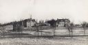
| Date: | 1872 |
|---|---|
| Description: | Wisconsin State Hospital for the Insane (Mendota Mental health Institute) is seen in the distance in this long view from across cornfields. |

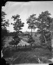
| Date: | 03 24 1913 |
|---|---|
| Description: | Picnic Point from the University Farm fields, now known as Observatory Hill. |
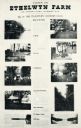
| Date: | |
|---|---|
| Description: | Ethelwyn Farm (The Teachers' Country Club), on Lake Monona. |
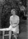
| Date: | 05 18 1944 |
|---|---|
| Description: | Helen Hall, secretary at the Youth Hostel headquarters on the Samuel Post farm on Middleton Road, near Shorewood Hills. |
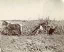
| Date: | 1902 |
|---|---|
| Description: | Left side profile view of a farmer using a horse-drawn corn binder in a field. |
| Date: | 05 24 1947 |
|---|---|
| Description: | Governor Oscar Rennebohm farm, on U.S. Highway 151, five miles east of the Capitol between Madison and Sun Prairie. Shows the barn and bungalow intended fo... |

| Date: | 05 24 1947 |
|---|---|
| Description: | Governor Oscar Rennebohm farm, on U.S. Highway 151, five miles east of the Wisconsin State Capitol between Madison and Sun Prairie. Shows the barn for youn... |

| Date: | 05 24 1947 |
|---|---|
| Description: | Governor Oscar Rennebohm farm, on U.S. Highway 151, five miles east of the Capitol between Madison and Sun Prairie. Shows a herd of Holstein cows and a far... |
| Date: | |
|---|---|
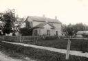
| Description: | View of a home on University Avenue, with a fenced-in yard and several trees. |
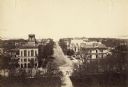
| Date: | 1887 |
|---|---|
| Description: | Elevated view of Wisconsin Avenue from the Wisconsin State Capitol building. Mansions and churches are along the road, and Lake Mendota and Picnic Point ar... |
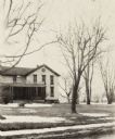
| Date: | 1920 |
|---|---|
| Description: | Exterior of house with porch and yard on highway 113. Snow is on the ground. |
| Date: | 1899 |
|---|---|
| Description: | University of Wisconsin-Madison College of Agriculture, looking southeast. Fences and fields are in the foreground. There are two windmills near buildings ... |

| Date: | 1956 |
|---|---|
| Description: | Aerial view over University Avenue of the University of Wisconsin-Madison campus, including University farm in the upper middle. The shoreline of Lake Mend... |
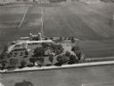
| Date: | 1946 |
|---|---|
| Description: | Aerial view of farm which is part of the University of Wisconsin-Madison. In the foreground is a tree-lined road. The farm has several buildings, including... |
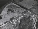
| Date: | 1958 |
|---|---|
| Description: | Aerial View of Eagle Heights Apartments, built especially for married students' housing, under construction on the University of Wisconsin-Madison campus. ... |

| Date: | 1914 |
|---|---|
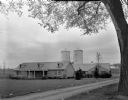
| Description: | View from field of farm buildings of the University of Wisconsin-Madison. Beyond a partially snow-covered field are several barns, and a large home to the ... |

| Date: | 1919 |
|---|---|
| Description: | View from field of stone house and farm buildings of the University of Wisconsin-Madison. A small open wood shed is on the right. |

| Date: | 1920 |
|---|---|
| Description: | University of Wisconsin-Madison farmhouse on Middleton Road. |
If you didn't find the material you searched for, our Library Reference Staff can help.
Call our reference desk at 608-264-6535 or email us at:

