 Filter: Categories of Wisconsin Historical Images
Filter: Subject of Farms
Filter: Creator Name of Unknown
Filter: Year of 1800-1899
Filter: Categories of Wisconsin Historical Images
Filter: Subject of Farms
Filter: Creator Name of Unknown
Filter: Year of 1800-1899
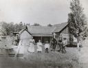
| Date: | 1898 |
|---|---|
| Description: | A man, his wife and their two children are posing in front of their farmstead. The man is holding a team of horses. Another horse pulling a buggy is in the... |
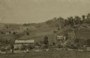
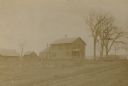
| Date: | 1875 |
|---|---|
| Description: | View from a distance of a farm in a valley owned by Alex(ander?) Smith. There is a wooden fence in the foreground surrounding the farm. |

| Date: | 1890 |
|---|---|
| Description: | Bird's-eye map of West Superior and Superior, with insets of Wright Farm and First Building in Superior. |
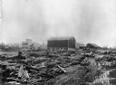
| Date: | 09 09 1881 |
|---|---|
| Description: | Wreck of the Chicago, St. Paul, Minneapolis and Omaha railroad line on the Teegarten farm near Menomonie. Dead cows are in the foreground. |

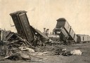
| Date: | 10 1891 |
|---|---|
| Description: | The wreckage of a head-on collision of two Chicago, St. Paul Minneapolis & Omaha Railroad trains at Tramway. Men stand near and on top of the railroad cars... |

| Date: | 1897 |
|---|---|
| Description: | View down dirt road, with a few homes on each side of the lane. |
| Date: | 1890 |
|---|---|
| Description: | Sweep horsepower threshing. Men and products lined up near the machinery with a large haystack on the left. |

| Date: | 1891 |
|---|---|
| Description: | Elevated view of a barn raising on the farm of Alva Paddock in the township of Salem on Geneva Road, Highway 50. |
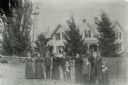
| Date: | 1898 |
|---|---|
| Description: | Group portrait of the Jacob Gasser family standing in front of the farmhouse at Tower Rock Farm. |
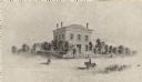
| Date: | 1897 |
|---|---|
| Description: | The Indian Agency House when the land was farmed by E.S. Baker of Portage, Wisconsin. |
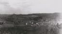
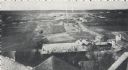
| Date: | 1880 |
|---|---|
| Description: | Elevated view from hill towards farm fields and houses. Tree-covered hills are in the distance. |
| Date: | 1871 |
|---|---|
| Description: | The building has a fence around it and the yard is filled with trees. Pedestrians are in the road, as well as a man riding a horse. |
| Date: | 1870 |
|---|---|
| Description: | Elevated view from rooftops of what was known as Watertown Plank road, looking west from about North 35th Street. Several homes, and many open fields occup... |
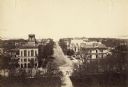
| Date: | 1887 |
|---|---|
| Description: | Elevated view of Wisconsin Avenue from the Wisconsin State Capitol building. Mansions and churches are along the road, and Lake Mendota and Picnic Point ar... |
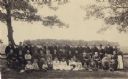
| Date: | 06 18 1890 |
|---|---|
| Description: | Group portrait outdoors of the reunion of Company F, 16th Wisconsin Volunteer Infantry, held at the farm of George W. Dibble in Rock County. Back row, left... |
| Date: | 1890 |
|---|---|
| Description: | A view of Rudolph Herrling's sawmill and log yard in front of the Herling farm. |

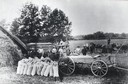
| Date: | 1880 |
|---|---|
| Description: | Group portrait of men and women posing in hop field. Most of the women are wearing aprons, and some of them are holding plants from the harvest. In the for... |

| Date: | 1882 |
|---|---|
| Description: | This manuscript map from 1882 shows land use and land for sale in a portion of the Town of Pewaukee, Waukesha County, Wisconsin. Woods, marshland, springs,... |

| Date: | 1898 |
|---|---|
| Description: | This 1898 map of Sawyer County, Wisconsin, shows the township and range system, sections, roads, farm houses, camps, school houses, dams, bridges, Indian r... |

| Date: | 1890 |
|---|---|
| Description: | This map shows the Wisconsin Central Railroad land grant lands owned and for sale by the Soo Line in Ashland County, Wisconsin, as well as in portions of B... |
If you didn't find the material you searched for, our Library Reference Staff can help.
Call our reference desk at 608-264-6535 or email us at: